Pinacate and Gran Desierto
El Pinacate y Gran Desierto de Altar Biosphere Reserve
Kino Explorer
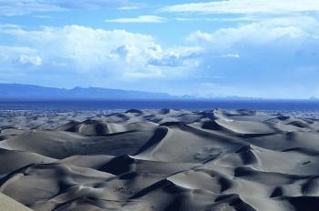
World's Highest Sand Dunes
Gran Desierto de Altar
Explorer Section Page Links
Kino Exploring The Gran Desierto

Pinacate Volcanics & Sand Dunes
International Space Station Photo
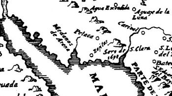
1698 Exploration
Middle Gila River to The Pinacate
San Serguio
Today's Quitovquito
Organ Pipe National Monument
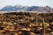
Pinacate Peaks
Santa Clara Volcano and Lava
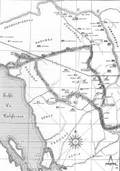
1701 Exploraiton
Pinacate & Return By San Xavier
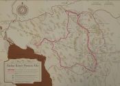
Harry Karns Map
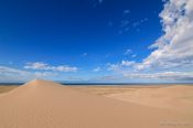
Sand Dunes & Gulf of California
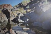
Petaca (Papago) Tanks
Singing Laurentian Litanies
With Our Lady of Loreto Banner
MacDougal Crater
Sierra Hornaday - center
View West Towards Colorado River
O'odham Salt Pilgrimage
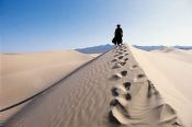
Trail to Gulf Coast
View From Pinacate Peak
To Gulf of California
Life Section Page Links
Website Page Links
- 'Home Page
- 'Page Index
- Best Concise Biography
- Best Book El mejor libro sobre Kino
- Best Book Entire Online English
- Best Book Guide Section Page
- Best Book Reference Map & Timeline Links
- Best Book^ Online Table of Contents
- Best Book^ C01 California Mission
- Best Book^ C02 Indians Not Slaves!
- Best Book^ C03 Among The Pimas
- Best Book^ C04 Young Lieutenant
- Best Book^ C05 Blood of a Martyr
- Best Book^ C06 Vengeance!
- Best Book^ C07 Children Ask For Bread
- Best Book^ C08 Error in the Map
- Best Book^ C09 Devil's Highway
- Best Book^ C10 Visit from Salvatierra
- Best Book^ C11 Plan for New Spain
- Best Book^ C12 General Manje Writes Report
- Best Book^ C13 Francis Xavier Chapel
- Best Book^ C14 Best Book Index
- Best Book^ C15 Author Bio & Note
- Biografía de Eusebio Francisco Kino
- Biografia di Eusebio Francisco Kino
- Biography of Eusebio Francisco Kino
- Builder Architect
- Cabalgata Rides 01
- Cabalgata Rides 02
- Cabalgatas Section Page
- California Builder
- California Founder
- Cartographer
- Cross References To Books
- El romance del Padre Kino Book
- Europe Son
- Expanded Table of Contents
- Explorer
- Explorer Baja California Gulf of California
- Explorer Colorado River and Delta
- Explorer Pinacate & Gran Desierto
- Explorer Sonora Arizona
- Farmer Rancher
- Favores Celestiales Bolton
- Friend and Defender
- Grave Discovery Chapel
- Grave Discovery History
- Grave Discovery Olvera Account
- Historian
- Horseman
- Jesuit Exemplar
- Jesuits on the Pacific Bolton
- Kino Biography
- Kino Heritage
- Kino Life
- Kino Life Summary Maps
- Kino Resources
- Kino Wheat
- Letters To Duchess Aveiro
- Literature Bibliography
- Magdalena de Kino - Trails End
- Magdalena Pilgrimage
- Mission San Xavier del Bac Statue Guide
- Missionary Father
- Multimedia Online
- National Parks and Heritage Areas
- O'odham People
- Pageant Play "Bell and Plow"
- Remembrances on the Trail
- Ride for Justice History
- Ride for Justice Journeys
- Sainthood Cause
- San Cayetano Tumacacori
- San Xavier del Bac
- Scientist
- Segno - Birthplace
- Sor Juana's Kino Poem
- Sortillion^ C01 El Joven Kino
- Sortillon Kino Website
- Statues Monuments
- Test Page
- Testimonials
- Timeline
- Tumacacori
- U.S. Capitol Statue Section
- U.S. Statue Burrus Dedication
- U.S. Statue Hayden Acceptance
- U.S. Statue Silver-Cruys Sculptor
- U.S. Statue Udall Interior Secretary
- U.S. Statute Goddard Presentation
- U.S. Statute Green Invocation
- Website Page Index Annotated
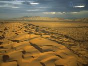
Largest Sand Dune Field
in North America
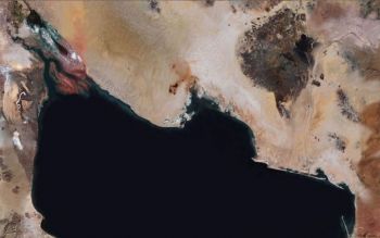
Colorado River Delta and El Pinacate y Gran Desierto de Altar Biosphere Reserve
Colorado River, Gran Desierto and Pinacate Region
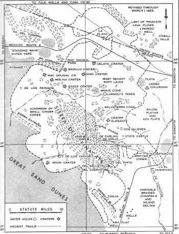
Detail of Kino 1701 Map
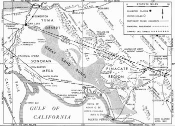
Colorado River, Gran Desierto and Pinacate Region
Ives 1966 Map
Kino's Exploration of the Pinacate Region
Account and Maps
Ronald L. Ives
Introduction
Two and a half centuries ago, the Pinacate region of Sonora, Mexico, was called the Sierra de Santa Clara and was the objective of four separate expeditions by Father Eusebio Francisco Kino. The contemporary narratives of these expeditions, found and translated by Herbert E. Bolton, and subsequently augmented by the findings of other scholars, are mines of fascinating historical, geological, and geographical information. Bolton, using the maps and geographic data published by Hornaday [1] and Lumholtz [2] worked out the approximate itineraries of the various Kino entradas. These itineraries were in accord with the evidence available to Bolton, and parts of them could be verified by field checking. Since the time of Bolton's work, however, our knowledge of the Pinacate region has been greatly augmented, so that a review of the itineraries proposed by Bolton is in order. This review, which makes use of much data not available to Bolton, shows the substantial correctness of his reconstruction, but it makes some parts of the itineraries more specific and discloses a few ambiguities and uncertainties which may be resolvable with further research. |24|
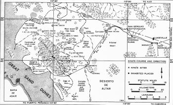
First Pinacate Summit
Kino Route 1698 Map I
First To Summit The Sierra de Santa Clara (Pincates)
October 1698
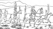
Kino's first journey to Pinacate, made in October of 1698, in company with Captain Diego Carrasco, and guided by the Indian governor and 'fiscal' (public prosecutor) of Sonoyta, included a number of important "firsts"; yet it was disappointingly documented even though both Kino and Carrasco wrote reports of the journey. [3] From Sonoyta, Father Kino and his companions journeyed four leagues westward to San Serguio, where, being assured that the journey to the sea was easy, they left many of their pack animals and much of their equipment. From San Serguio, they traveled eighteen leagues (about forty-seven miles) "over a very good road with plentiful running water, grass, 'carrizales' [cane, common reed, or 'carrizo' ('Phragmites')], and 'tulares' [tules, or cattails]" and came to a small ranchería where the natives gave them calabash and other foods. This camp was named Santa Brigida.
The next day, October 9, with guides (apparently from the settlement of Santa Brigida), they traveled "seven leagues eastward" to the summit of the Sierra de Santa Clara, from which Father Kino observed the Sonoran shore and the Gulf of California, and saw clearly the junction of the Gila and Colorado rivers. He did not, however, on this journey, see the junction of the lands of Papaguería with those of California. This was the first recorded ascent of Pinacate Peak by Europeans. That night they returned to Santa Brigida. On October 10, they retraced their outward journey, covering the entire distance from Santa Brigida to Sonoyta, twenty two leagues, or about fifty-seven miles, in a single march.
Those not familiar with Father Kino's travel rates may be surprised at the pace of this journey, which covered fifty-one leagues, or about 133 miles (a league of that time was about 2.6 miles [Leagues differed in length and in Ives's own words were somewhat "elastic" [4] ] in three days, but that was a rather moderate journey. Actually Father Kino was not at his best on this entrada, for he had been quite ill on September 30 and October 1 of some fever. He was, incidentally, fifty-three years of age at that time.
Despite the terseness of all of the documentary evidence, most of the sites mentioned, and parts of the trail followed, can be relocated with some confidence. The probable itinerary of the 1698 entrada is shown on Map 1. [5] The Sonoyta here referred to is the San Marcelo de Sonoyta of many of the Kino documents, and is the old townsite, about one and one-half miles upstream (east) of the present Mexican community of the same name. Ruins of the mission built there later by Father Kino, and destroyed during the Pima revolt of 1751, are still visible (1964). The townsite was moved downstream from its ancient location after a sudden lowering of the local water table in 1891. [6]
San Serguio, from its stated location and from numerous contemporary descriptions, is surely Quitovaquito, an ancient Papago camp at a group of small springs almost exactly on the present international boundary. From about 1870 to about 1955, Quitovaquito was the home of a group of Areneño Papago, of whom José Juan (Orozco) was perhaps the best known. The pond at Quitovaquito mentioned by Bolton [7] is relatively modern, having been built by José Juan and his family with the assistance of the United States - Mexican Boundary Commission about 1890, when a field observatory was established at the little oasis for the determination of longitudes. [8] The springs, however, are ancient, Quitovaquito having been a "port of call" for many centuries before Kino's time. |26|
The probable route from Sonoyta to San Serguio was the traditional Papago trail, which ran westward from the old Sonoyta townsite across the flatlands on the south bank of the river to the abandoned Papago 'temporale' (temporary farming area) of Tjutshpa. Here, during the 1870s, flourished Santo Domingo, the short-lived hacienda of Cipriano Ortega. To the right of the old trail, just east of the Santo Domingo townsite, on a small granite knob at the south edge of the bed of the Sonoyta River, is a small prehistoric 'trinchera' (Indian defensive work), perhaps the westernmost in the Sonoyta Valley. [9] From the Santo Domingo ruins, the traditional trail angles northwestward, across the river, to Quitovaquito.
It is quite certain that the Kino party of 1698 did not follow the more logical path on the north bank of the Sonoyta River, for that bank is an area of bad going, being cut by many gullies carved by the torrential runoff from the southern part of the Puerto Blanco Mountains. Although these gullies were deepened by the relatively recent cycle of arroyo-cutting (1875-1935, approximately), they were deep enough to be an "obstruction to navigation" in much more ancient times, having been specifically mentioned as such by Pedro Fages in 1781. [10]
Westward and southward from San Serguio (Quitovaquito) for a considerable distance, the party followed the course of the Sonoyta River, which at that time was flowing freely, indicating that the summer "monsoon" storms of the area had been plentiful that year. The trail followed was undoubtedly the traditional Papago one, on the north and west side of the river, about as far as the south end of the gap through the Batamote Hills. The 'carrizales' ... mentioned in the diaries are still present, growing on the west side of the modern river channel, between the water holes now known as Agua Dulce and Agua Salada. Despite erosion by desert floods, and much wear by more or less modern vehicles, ranging from water wagons to jeeps, many sectors of this ancient trail are still visible.
None of the water holes along the Sonoyta River are mentioned in the diaries of this entrada. This omission is understandable, for, when the river is flowing steadily, the water holes at Agua Salada and Batamote are submerged by the stream. Los Pozitos may or may not have existed as a watering place in Kino's time, as it is largely manmade, and much of the excavation there was done by Cipriano Ortega's laborers about a century ago.
On leaving the Sonoyta River, the party passed to the southeast of the Sierra de Santa Clara, as was plainly stated by Carrasco. [11] A normal, logical, and traditional route for this journey is in a straight line from the south end of the Batamote Gap to the low pass between Pinacate and Sierra Blanca. As this route crosses a smooth outwash apron, no trail can be found in the first five miles (southwest from Batamote), but a typical Papago foot trail is present in many places from the edge of the Pinacate lava field to, and beyond, Tinaja de los Chivos.
Stopping place at the end of this day's journey was "la ranchería de la mar," a place with 'agua dulce,' roughly west of Pinacate and about eighteen leagues from San Serguio. This was named Santa Brigida and had a population, at the time of the entrada, of about twenty natives. |28|
On the following day, October 9, 1698, with native guides, the party journeyed "seven leagues eastward" (according to Bolton) to the summit of the Sierra de Santa Clara, and observations were made from the summit, including a sight of the junction of the Gila and Colorado rivers, which is ninety-four miles distant from Pinacate Peak (4,235 feet) and has an azimuth of 328 degrees (bearing N. 42° W.). Although this course and distance is necessarily approximate, for the Gila-Colorado junction has shifted position many times during recorded history, the difference between the modern location and that seen by Kino probably does not exceed five miles. This river junction is commonly visible from Pinacate Peak during the cooler months of the year, but is usually concealed by shimmer and mirage during July, August, and September.
Although the water hole and campsite of Santa Brigida is nowhere clearly described in the narrative, its distance from known points is given, so that its approximate location is roughly determinable by the method of intersection. The most probable location of Santa Brigida is within a zone about two leagues wide, centered on the meridian through Tinaja de los Chivos. Now, from Santa Brigida, the party journeyed "seven leagues eastward" to the summit of the Sierra, if we accept Bolton's reconstruction literally. A point seven leagues west of the summit of the Sierra is in the Great Sand Dunes, near the southern end of the Sierra Enterada, where the Kino party definitely did not go on this entrada. There is an error of closure here of at least three leagues. Additionally, a day's journey of fourteen leagues, which included the ascent and descent of Pinacate Peak (an altitude change of about 3,600 feet), would have tried even the stamina of Father Kino. Reference to Kino's diary" indicates that the "como 7 leguas de camino ... " could refer equally well to the entire day's journey or to the one-way distance traveled. If we accept the first alternative, then Santa Brigida is three and one-half leagues by trail from the summit of Pinacate Peak, and plotting puts it again in the vicinity of Tinaja de los Chivos.
From these considerations, Santa Brigida is placed in an "area of uncertainty" (dotted outline, Map I) about Tinaja de los Chivos. No specific water hole identification is possible from the evidence given, but there are at least six semipermanent water holes in the area, as well as at least an equal number of "thirty-day tanks," many, of which were probably full at the time of Kino's visit, as rains were plentiful in the fall of 1698. [13]
The return from Santa Brigida to San Marcelo de Sonoyta, made in a single day, October 10, 1698, was completely uneventful, the outgoing trail being retraced in its entirety. The return to Mission Dolores was made via Caborca.
The documents of this entrada supply us with two interesting pieces of information not detailed by Bolton. The Sierra de Santa Clara was not specifically so named by Father Kino, but was identified as the sierra "que los antiguos cosmógrafos en sus mapas llamande Santa Clara" [that the ancient cosmographers called Santa Clara on their maps]. Both Kino and Carrasco state that they "were in "32 grados," on the basis of astrolabe determinations by Father Kino. The actual latitude of Pinacate Peak is 31° 46 1/2' N., according to the best modern determinations, which may be in error by a minute or so. Kino's error of determination was approximately thirteen and one-half nautical miles, which is surprisingly small considering the limitations of the instruments at his disposal and the state of the navigator's art in 1698.
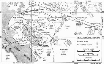
First and Second Entradas in Pinacate Volcanic Fields
Kino Route 1701 Map 2
Tres Ojitos (Chivos) and Gulf Coast
First Entrada Spring 1701
The two entradas of 1701, made in company with Juan Maria Salvatierra, S. J., and Captain Juan Mateo Manje, consisted of a journey to the Gulf of California via the southwest side of Pinacate and the great "médanos de arena" [sand dunes]; and the first visit by Europeans to Papago Tanks, an important water hole northwest of Pinacate. Most happily, these entradas are excellently documented, the Kino diaries and notes being augmented by the reports of Father Salvatierra, [14] and by the extensive diaries of Captain Manje. [15] The time of these journeys - mid-March to early April - coincides with the driest part of the year, and also with the beginning of the hot season. Midday temperatures, at this time, commonly rise into the nineties, forage is at a minimum, and windblown dust, caliche, and volcanic ash are common sources of added discomfort.
On this expedition, Father Kino left Mission Dolores on March 1, 1701, and arrived at San Marcelo de Sonoyta on the fourteenth. after a tour of a number of missions and settlements in the valley of the Rio Concepcion. Drought made parts of the journey from Caborca to Sonoyta quite difficult, according to Manje. Reconstructed itineraries of the two entradas of 1701, from San Marcelo west, are shown in Map II.
After resting a day in Sonoyta, during which two beeves were slaughtered, supplies were made ready, and the mail read, the party set out "westward for the Sea of California," stopping for the night at El Carrizal, "a canebrake with very good pasturage, water, and wood." The Pima guides called this place Comaquidan; Salvatierra named it La Anunciata.
The trail followed from Sonoyta to El Carrizal was almost certainly the traditional one on the south side of the Sonoyta River, paralleling the river bed to a point just beyond the Santo Domingo ruins, then cutting across a bend in the river, thereby avoiding some small granite hills (Los Cerritos de Agua Dulce), to a point about midway between Agua Dulce and Agua Salada. Manje describes the still-extant site most clearly, [16] stating that "At this place |31|
the water commences to be oily and brackish in taste, perhaps because of the saltpetre that is to be found here." This exactly describes the condition just upstream from Agua Salada, where the Sonoyta River leaves its incised channel and flows out upon the surface of a playa, floored with sand, gravel, volcanic ash, and caliche. This playa, the bed of extinct Lake Diaz, extends southward to the Batamote Hills. The canebrake from which the site takes its name is still present as an arcuate growth, perhaps 500 feet wide and half a mile long, paralleling the present river bed on the west side. Its former extent was considerably greater, as is indicated by root structures in areas not now supporting cane growth. The most popular campsite at El Carrizal, from prehistoric times until a few years ago, was a dry, smooth gravel bed roughly in the center of the canebrake. Kino's 1701 map ("Paso por Tierra a la California"), however, shows the campsite on the east side of the river. As there is a historically ancient, alternative, abandoned river channel on the west side, it seems probable that the Sonoyta River channel shifted after 1701, and some time before 1907. [17] |32|
At El Carrizal, the party rested for a day, waiting for guides, and deciding upon which route to take around Pinacate. A southerly route, similar to that already followed by Kino in 1698, was finally decided upon. On March 18, the party set out southwestward, down the Sonoyta River (dry channel) and traveled ten leagues over stony plains, arriving at a poverty-stricken village of perhaps two hundred souls, living about an inadequate water hole, dug by hand in the dry river bed. This, called Sicobutobabia, [18] required further excavation by both fathers, but, even after laborious improvement, did not supply enough water for the animals.
In a "cave" near this site, probably a rock shelter, they found an old woman who, according to Salvatierra, "was the very picture of senility-so decrepit that she was all skin and bones, and everybody declared that she must be more than a hundred years old." She was catechized, signified a desire to be baptized, and "received the water of holy baptism, being called Mary, since through Mary the great happiness came to her." Apparently, Mary of Sicobutobabia was Father Kino's only adult convert among the Areneño Papago. [19]
The description of the water hole and the general environment exactly fits the site now known as Batamote (Map II), and bears no resemblance to any other water hole in the general area. Trail distance from El Carrizal (ten leagues) is somewhat excessive, but the overestimation may be due to the bad going at the time of the journey. It is about seven leagues from El Carrizal to Batamote by the conventional trail on the west side of the Sonoyta River. When the ground is firm, as [it is] a few days after the summer "monsoon" rains (October conditions), it is an easy six-hour walk from Batamote to El Carrizal. When the ground is powder dry (usual March and April conditions), the same journey is an exhausting all-day drag.
On March 19, the party traveled southwestward five leagues over level sand- and ash-covered malpais to a village and great tank called El Basoitutcan. [20] South of this, at the foot of Santa Clara Mountain, was a village where "we counted 50 persons, poor and naked people who sustain themselves by roots, locusts and lizards, |33| which they call iguanas, and some fish. All these Indians were instructed in the Word of God. [21]
On arriving in the area of Basoitutcan, the animals had been without water for approximately thirty-six hours, so that their situation was precarious, despite good grass (galleta) in the area. The first water hole shown the explorers by the natives was inadequate, so that only about a fourth of the animals could drink. The expedition either had to find more water or to turn back.
Father Salvatierra, accompanied by the soldier Tomas Garcia, set out on a search, and the soldier shortly found a tank "so abundant that four hundred animals all at once might drink at it for a long time." In the meantime, Father Kino met two old Indians bound for Sonoyta with a load of salt and persuaded them, by the gift of a cowhide and the promise of more, to point out still an other water hole. It being the Feast of San José, the place was named San José de Ramos.
Course and site identifications here present no problems. Tinaja del Cuervo is almost exactly five leagues by trail from Batamote, and the general direction is southwesterly. The first tank reached by the party was probably Tinaja del Galletal, the least dependable major tank in this group. The enormous water hole found by Tomas Garcia while searching in company of Father Salvatierra was probably Tinaja del Pinto, the water content (estimated at 2,000 gallons) being about right for that tank in an aver age spring. The third water hole, shown Father Kino by the salt gatherers, was probably Tinaja del Cuervo, the traditional stopping place for Papago salt expeditions. Clear descriptions of these holes are given by Lumholtz. [22]
The Indian village south of San José de Ramos was probably at the northwest edge of a temporale which, despite almost a century of disuse, was still visible in 1954. [23]
The next day, Palm Sunday, March 20, 1701, was started with the traditional blessing of the palms. Immediately thereafter, the party started westward from San José de Ramos, passing through the gap between Pinacate and Sierra Blanca. Late in the day they arrived at El Tupo, "a tank of rainwater in an arroyo filled with boulders and lava." On arriving at El Tupo, Father Kino climbed a |34| nearby lava hill and "descried California very plainly, to the west and southwest." Captain Manje accompanied him, and later the soldiers and others of the party also saw California.
During this sector of the journey, the literate members of the party did extensive observing and thinking, with the result that Pinacate was identified as an extinct volcano (correctly) many years before the "classical" identification of an extinct volcano by Desmarest and Guettard. Salvatierra, in describing the "horrible volcano," states: "I do not know that there can be any place which better represents the condition of the world in the general conflagration." [24] The Kino and Manje narratives also describe the volcanic features of the area in some detail, with plentiful speculations as to their origin. This fascinating piece of geological deduction has been detailed elsewhere, with references. [25]
El Tupo was a water hole in the Chivos group. It could have been the modern Tinaja de los Chivos, from the general description, but several other tanks in the immediate vicinity also meet this description. The name is a direct rendition of the Papago name for tank, spring, or water hole, whose approximate pronunciation is "choopo." Although certainly very near to the Santa Brigida camp of the 1698 entrada, El Tupo was pretty surely not the same water hole, as the name Santa Brigida was not reused.
On Monday, March 21, 1701, in view of the waterless journey across the sand dunes between El Tupo and the Gulf of California, the party was divided. The pack train and some of the personnel, including a few deserters, remained at El Tupo, while the fathers, Captain Manje, and most of the soldiers made a difficult march across the "médanos de arena" to a group of three small springs near the shore of the Gulf. Camp was made at this site, which they named Tres Ojitos. The native name for Tres Ojitos, as given by Manje, is Cubo Quasivavia. [26] Measured latitude here was found to be 31°.
Kino's estimate of the distance traveled between El Tupo and Tres Ojitos was eight leagues. Actual distance is nearer five leagues, the extra mileage possibly being accounted for by the circuitous course taken by the horses to avoid the "bad going" in the sand dunes. In this area, a man afoot can travel faster and farther than a |36| horse, and it is commonly reputed (not entirely correctly) that "a horse that goes into the "médanos" never comes back." Lumholtz describes this area, and travel in it, quite accurately [27] The modern Mexican name for the general area is La Soda. The water supply at Tres Ojitos seeming adequate, the fathers sent to El Tupo for the pack train and the rest of the horses.
Immediately on the arrival at Tres Ojitos, Father Salvatierra, "without dismounting, went toward the sea as far as half a league from this place, where before sunset we distinctly and with great clarity saw California and the cordillera, and still more clearly after sunset, when it appeared to us that the sierra must be distant from us about ten or twelve leagues. [28] The good father's observations were facilitated, but his distance estimates invalidated, by the usual late afternoon mirage of the area (a form of "looming"). In this same area today, as the sun sets, the Sierra La Encantada, in the Sierra San Pedro Martir of Baja California, seemingly rises out of the sea to a great height and with great clarity of outline, and remains visible on the western skyline until darkness sets in. [29]
A diligent search was also made on the beach for blue shells and mother-of-pearl shells, and none were found. "The Indians said that the blue shells came from the other side; farther on, and not from this sea." This gave support to Father Kino's hypothesis that the blue shells of the abalone came only from Pacific waters, and that their presence in Papaguería indicated overland passages from California. [30] Father Kino's study of the blue shells was probably the first use of biological tracers in North American history.
Although both the mountains of Papaguería and those of California could be seen from Tres Ojitos, neither the head of the Gulf of California nor the continuity of the mountain ranges could be seen from this site. Both the elevation of the Sonoran Mesa and the curvature of the earth conceal the mouth of the Colorado from an observer at La Soda; and the Sierra del Rosario, about forty miles northwest of La Soda, blocks view of the more distant mountain ranges. In consequence, plans were made for Father Kino and Captain Manje to make a further journey up the Sonoran shore of the gulf. This, however, was found impossible, due to lack of water and the condition of the animals. |37|
When the pack train arrived the next day (March 22, 1701), the small springs at Tres Ojitos failed to refill during the night, and only thirty or forty of the animals could drink. Investigation of another reported water hole up the beach (west, probably Tule Water, about six miles distant) showed that it also was inadequate. The party could not advance, and Tres Ojitos was untenable.
On Wednesday, March 23, after mass, the party retreated across the sand dunes to El Tupo, where the deserters were picked up, and the water was found too low to supply the entire 'caballada.' In consequence, the exhausted animals were driven at night to San José de Ramos, where the first arrived shortly after midnight, the rest arrived during the day of the twenty-fourth, except for nine that collapsed during the journey. Apparently due to the all-night march (for most of the party), Kino and Manje disagree by one day in the journal entries here.
Thursday, March 24, was spent at San José de Ramos so that the animals could rest and recuperate. The fathers, however, seemingly needed no rest, but celebrated mass and spent the day conferring with Indian visitors, including some from a great distance to the northwest. These, who "drank so many ollas of water that only a mule could equal them," told of some Yuma friends a day's journey distant and of some Quíquimas a day beyond them. After a conference with the fathers, a messenger was sent to summon the friends.
The next morning, March 25, Good Friday, a Yuma arrived. Father Salvatierra, noting that some of the words in his language were like those in the Cuchimi language, spoken near Loreto, Baja California, gave the messenger a letter to Father Francisco Maria Picolo (stationed at Loreto at the time) "entrusting it to the good fortune of reaching there." It did not. Then, "the sun being already high," and the conferences and visits concluded, the party of thirty eight left San José de Ramos, traveling back over their outward trail, and made camp that night at El Carrizal. Some of the exhausted pack animals did not arrive until two days later.
First and Second Entradas
Kino Routes 1701 Map 2
Petaca (Papago Tanks) and The Sierra Hornaday
Second Entrada
Spring 1701
On Saturday, March 26, 1701, the party rested in a good camp at El Carrizal, built a ramada in which to celebrate Easter, and Father Kino measured the latitude with his astrolabe, finding it to |38| be 31° 10'. The modern determination puts this at 31° 56 1/2'.
On Easter Sunday, March 27, 1701, according to Father Kino, their party received communion, and Salvatierra preached to them. "We made a little sketch of this extremity of the sea of California." The pack animals that straggled in during the day were allowed to rest and drink for another day, and then were sent on to Sonoyta with much of the baggage for further needed rest and recuperation. The various narratives here are slightly out of phase, but all agree as to what was done.
Monday was spent in camp, awaiting visitors, and a messenger was sent to Sonoyta for "a beef and fresh meat," which arrived the following day. On the same day, Tuesday, March 29, many visitors came from the east, and six of these went on a "new little journey to the westward," accompanying the fathers and Captain Manje. This was a search for a route to the land of the Quíquimas, and reached nominal latitude 31° 35'. The best guess is that the actual journey was about thirty miles to the northwestward, and that the point of return was somewhere near the western end of the O'Neil Hills. As specific data are lacking, itinerary of this journey is not shown on Map II. "On the thirtieth," says Father Kino, "we awaited our news from the west, which, however, did not come."
The second major entrada of this pair began on Thursday, March 31, 1701. Carrying the standard of Our Lady of Loreto, Father Kino, Father Salvatierra, Captain Manje, six Pima guides, eighteen mules, and three horses, with six light loads, set out westward from El Carrizal. According to Kino's terse and lucid account, as translated by Bolton: [31]
"Having marched a little more than thirteen leagues and leaving far behind the Cerro de Santa Clara, which was now to the south of us and hidden by other peaks, the Indians told us that we were now near the camping place. Although the sun was about to set, and we were tired, in order to save distance we decided before going to the camp site to ascend a very high peak which there is to the west. It is very difficult and we went up rather on all fours than on foot, but in spite of this trouble we carried up the standard.
The sun set, and from the peak we saw with all clarity all the sea below, toward the south, and the place on the beach to which we had descended. We saw that the half arch of sierras of California |39| whose end had been concealed from us by the spur of the mountains kept getting constantly closer together and joining with other hills and peaks of New Spain.
With this view of the strait we sang the Lauretanian Litanies to Our Lady as a sign of thanksgiving, and then we descended from the peak to the village called Pitaqui." [32] [Editor Note: To hear Mozart's Laurentanian Litanies, click Litaniae Lauretanae de Beata Maria Virgine]
One of the Indians, "a chief," who made the ascent of the high peak with the fathers, pointed out the place where the Quíquimas lived, and explained that the blue shells which so interested Father Kino came from the sea beyond the Gulf of California.
To clarify the itinerary of this journey further, Father Kino on his famous "Paso por Tierra" map (1701) shows Petaca northwest of Pinacate and a high peak just north of Petaca.
With these facts, plus some terrain knowledge, the itinerary of this entrada can be reconstructed in considerable detail, and is shown on Map II. La Petaca, with its three pools of rain water, is surely Papago Tanks (Tinaja de los Papagos). There is no similar group of water holes anywhere in the vicinity. The route from El Carrizal to La Petaca is the old northerly Papago trail, which passed just north of the Cerro Colorado playa, crossed the southern end of the gravel-floored embayment in the Pinacate lava field, known as La Playa, crossed an arm of the lava, and then turned southward at the western edge of the lava, passing between the lava and the Sierra Hornaday. The "very high peak" climbed by the party must have been the Sierra Hornaday, and the difficult ascent was up the east side. There is an easier route on the north face. The Sierra Hornaday is a granite fault-block mountain rising roughly 800 feet above the surrounding terrain. From its summit can be seen all of the things described in the Kino accounts, and the visibility is greatly enhanced, late in the day, by the local mirages.
It was from this summit, almost certainly, that the "great hole which caused terror and fear" was seen, as an observer looking southward from the crest of the Sierra Hornaday looks directly into MacDougal Crater, a steep-walled depression slightly less than a mile in diameter. Late in the day, when the sun is low, this crater, viewed from above, appears bottomless. |40|
That evening, Father Kino preached to some native visitors and baptized some of their children. The morning of April I was spent in conferences with Indian visitors - Yumas, Pimas, and Cocomaricopas - some of whom were known to Father Kino. In the afternoon, the party started back toward El Carrizal and made a dry camp in an area of abundant pasturage, but no water. Manje states that they had carried some drinking water in gourds from the pools at La Petaca. The site is designated by "Dry Camp" in Map II. Leaving this camp on Saturday, April 2, 1701, the party traveled the entire seventeen leagues to San Marcelo de Sonoyta with only a brief stop at El Carrizal to water the animals.
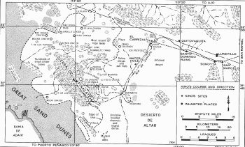
Kino Route 1706
Map 3
Night on The Sierra de Santa Clara (Pinacate Peak)
November 1706
Father Kino's last visit to Pinacate was made in the fall of 1706 for the specific purpose of showing official witnesses the evidence for the pen insularity of California. It was undertaken with the support of General Don Jacinto de Fuensaldaña, commander of the presidio of Fronteras. Alferéz Juan Matheo Ramírez and Commander Juan Antonio Durán were detailed as military escort. Ramírez was charged with the preparation of the official diary of the expedition, to be signed by all, and then to be conveyed, by a courier supplied at the general's expense, to Mexico City, "and even to His Royal Majesty."
Also accompanying the expedition was Fray Manuel de la Oyuela y Velarde, a Franciscan who was in Sonora soliciting alms. He prepared a separate and independent report of the trip, which supported and confirmed the official diary. [33]
Bolton gives a terse and readable summary of this expedition. [34] Details of the itinerary are found in the diaries of Ramírez [35] and Oyuela. The Kino party entered the area of our immediate interest via Caborca and Quitovac, arriving in Sonoyta on Tuesday, November 2, 1706. Here they received a herd of cattle sent from San Ambrosio de Busanic by a direct route, and conferred with many Indian visitors, including "the captain and the governor of the Yumas, the governor of the Cocomaricopas," and others who had journeyed great distances to see and hear Father Kino.
Wednesday, November 3, 1706 - all day and far into the night - was spent in a continuous round of missionary activity, detailed by Ramírez, and commented upon with approval and awe by |41| Oyuela. Although Father Kino was sixty-one at this time, he was still able to ride all day and then preach and confer most of the night when the need arose.
Departure westward, for El Carrizal, was delayed until midday of Thursday, November 4, by the large number of visitors at Sonoyta. These having finally been sent on their way "contented and comforted" by promises of further missionary efforts, the cavalcade (sixty-five horses and mules) took the trail westward to the now-familiar canebrake on the Sonoyta River.
Starting at dawn on Friday, November 5, Father Kino led the party "four leagues forward to say Mass at a very good water hole." After breakfasting there, they went ten leagues more to "a tank with water held in between the rocks of a very high peak which they called Cerro de Santa Clara." There the party ate, left the relay horses, some of the boys, and Commander Durán, who was ill.
Then, "selecting the best mules, we ascended this very high peak, which was four leagues more in ascent. On this peak, three others are piled up. We ascended the one which slopes to the south, whence was seen the sea, which was exactly to the south of us." After making other observations, detailed by Ramírez, "we slept on the summit of this hill, commanding a view of land for more than forty and fifty and sixty leagues distant."
On Saturday, November 6, "as soon as day dawned Fray Manuel de la Oyuela went down this little southern ridge and ascended the other, which was the highest of all." The observations of the previous evening having been repeated, so that everyone was satisfied that the land and sea relations were as previously stated by Father Kino, the main party descended to where the mules had been left. The mules were saddled while Fray Manuel descended from the highest peak, and all rode down the four-league hill to the water hole. There, Father Kino said Mass "in thanksgiving for the so plainly discovered certainty of" the land passage to California; the party breakfasted, and all rode fourteen leagues back to El Carrizal, where they spent the night. "On the seventh, Sunday, we arose early, and came in time to say and hear Mass to San Marcelo." The rest of the day was spent in conferences with visitors, |43| among them being "the captain of the Cocomaricopas of the Rio Grande or Rio de Yla." On Monday, November 8, 1706, the party left San Raphael del Actum, and out of the area of our immediate interest, in the first march.
The itinerary of this entrada is shown in Map III. The first leg of the journey, from Sonoyta to El Carrizal, was over familiar ground. The water hole at which Father Kino said Mass on the morning of November 5 was most probably within about a mile of the site marked "Water Hole" in Map III. This was probably a 'charco' (intermittent pool) in the dry bed of the river. As the river channel from Los Pozitos to about a mile north of Batamote is unstable, changing somewhat after each severe flood, exact site identification is impossible.
The water hole at which the relay horses were left during the ascent of the main peak is unnamed in the narratives, but only six known 'tinajas' at Pinacate are "held in between the rocks" of "the very high peak." Of these, only four, Oje de Iitoi, [36] Pinto, Galletal, and Cuervo are roughly four leagues from the summit. The water hole used was almost surely either Tinaja del Galletal or Tinaja del Cuervo. Both are about four leagues by trail from the summit; both are about fourteen leagues by trail from El Carrizal; both are just west of an area of good grazing. As both narratives lack detail, we cannot state, with any assurance, which of these two water holes was used.
The peak on which the party spent the night of November 5-6 was most probably what is now known as Carnegie Peak (just under 4,000 feet, Map III), although it could have been a slightly lower unnamed peak rising from the same sub summit plateau. The highest peak, climbed by Fray Manuel, was certainly Pinacate Peak (about 4,000 feet, Map III), which, as he so clearly states, is "a sort of rubbish-heap of 'tezontle stone'." His comment on the difficulty of the ascent, made "at the cost of very great toil ... so that I seemed likely to end my life sooner than the undertaking," suggests quite strongly that this was the hardest part of the whole journey. Such would be the case if the ascent were made from the Cuervo Galletal area, but not if the ascent were made from the northeast |44| side of the peak, where the terrain is considerably roughened by a lava cascade.
Observations made from the summit by the Spaniards were in exact accord with what can be seen from the summit on any clear day. A thorough check of the narratives will clearly show that both Alferéz Ramírez and Fray Manuel de la Oyuela were careful and competent observers and honest reporters. Herbert E. Bolton, using the information available about 1930 [37] proposes that the water hole at the foot of the Sierra de Santa Clara was Tinaja de Emilia. Although the main peaks could be reached via this tank, the ascent from the tank to the peaks would be most difficult for a horseback party, and the tank is considerably less than two leagues from the summit, the ascent afoot requiring less than two hours (3,000-foot altitude gain, approximately) for a man with a full canteen. Had this route been used, we would expect mention, in the narratives, of the lava chaos (to the right as the tank is approached), of the numerous pools at Emilia, and of the difficulty of the ascent to the subsummit plateau. Had Fray Manuel traversed this route, he would have found the ascent of Pinacate Peak easy by comparison, and he would not have commented on the "very great toil."
This reconstruction of the itineraries of the four Kino entradas has described routes with which the documentary evidence, and the geographic evidence, are in close accord. Many of Kino's sites can be identified specifically with known modern sites, and the routes followed by the Kino parties likewise can be determined with some confidence. In a few instances, only the general area visited can be determined from the documentary evidence. These evidential ambiguities will only be resolved by the turning up of more evidence, either documentary or archaeological. Although we believe that all major documentary evidence has come to light, it is entirely possible that some minor document, such as a soldier's letter to his wife, may be found later to contain pertinent evidence. |44|
Dr. Ronald L. Ives
"Kino's Exploration Of The Pinacate Region"
"Land of Lava, Ash, and Sand
The Pinacate Region of Northwestern Mexico" 1989
Originally published in
Journal of Arizona History
Summer, 1966 Volume 7
Sand Dunes of the Gran Desierto
Kino's Failed Crossing of the Gran Desierto 1702
Sunrise Over the Gulf and Tradegy on the Trail
Herbert E. Bolton
González arrived from Oposura at Dolores on the last days of January, 1702, with servants, fifty mules, and provisions, ready for the new expedition. To this equipment Kino added twelve servants, a few more loads of provisions, and eighty horses and mules. It was another Kino cavalcade. ....
"Hoping to catch sight of the Contra Costa and the South Sea," on February 5 they set forth. From Dolores they went by way of Remedios to Síboda, where now there were "more than a thousand cattle and seven droves of mares belonging to the new conversions." At Santa Barbara, a short distance beyond, Kino left stock for "another little ranch ... for these roads to the land passage to California." Continuing to Búsanic, he crossed Pápago Land by yet another route to Sonóita, and from there followed the Camino del Diablo to La Tinaja, the tank in Gila Range.
Here they were detained two days by a terrific cloudburst, which sent the water roaring and tumbling down the narrow canyon and greatly swelled the stream that supplied the basin. ... |479| The spot is memorable for another incident. While in camp here Kino observed a comet "in the Constellation of Aquarius." ....
Proceeding to San Pedro on the Gila, they followed its course northward downstream. "After going four leagues," says Kino, "we arrived at the opening where it may be said that California Alta begins, because its meridian passes through the middle of the head of the Sea of California." They were now about at Dome, where the river cuts through Gila Range. Kino's assertion regarding the meridian is essentially correct. He thus put the Colorado River within California. Next day they reached San Dionisio, head village of the tall Yumas. González was delighted with the place. "Well might one come all the way from Mexico to see it, on account of its very sightly groves, its copious and peaceful water, its fertile lands."
They were ready now for the main problem. Starting downstream on March 1 with a great following, they visited Santa Isabel, passed San Feliz and the November crossing, and continued to San Rodesindo. Here in the midst of a great assemblage of natives they arranged "for the descent to the very disemboguement of these rivers in the sea." ....
Here at San Rodesindo Kino took the latitude and found it to be in 31 1/2 degrees, - that is, half a degree below his November crossing. It was in fact above 32 degrees. Next day they continued down the river to San Casimiro. ... On the 5th they went straight south to the bayous of the Gulf, accompanied by Quíquimas, Cutganes, and Cócopas, the lastnamed people having come across the river from both west and southwest. Kino now made minute inquiry about tribes, mountains, and rivers to the west ...
A day was spent teaching the Faith and giving canes of office to the Indians from the west. On the 6th, Kino made all possible efforts to cross the Colorado, but the bogs prevented "because it had rained these days." On the 7th, González "descended to the very mouth and to the sea by a westward course, and I, having collected information for us concerning all these natives of the west, and sent my messengers ahead to those on the other bank of the river, descended in the afternoon, having been detained by the continuous messages which they were sending me." As he traveled Kino's fame spread.
Next day more than three hundred Indians, great and small, swam across the Colorado to see him, bringing "blue shells from the opposite coast," [481 } and towing great baskets of provisions, to urge him to cross the river to visit them. But Father González was now very ill - had been, indeed, during the whole expedition - so they decided not to cross over, promised to come again, and returned to San Casimiro.
But Kino could not make this decision stick. "On the ninth," he tells us, "so much were we moved by the petitions and desires of the natives on the other bank of the river, and so great was our desire to cross and see the Río Amarillo, and even to cross to the Sea of the West, or sea of the opposite coast, or South Sea [the Pacific Ocean], since we were assured that it was not more than eight or nine days distant, and since they brought us some little pots and other gifts which previously had been brought from the opposite coast, I decided to descend once more to the mouth and with the natives to cross the Río Colorado, and for this purpose we equipped ourselves with the necessary provisions and the best horses."
So next day they went again down to the mouth, "taking and joining many dry poles to make a very great raft on which to cross the very large volumed and very wide Río Colorado, Río Grande de Hila, and Río Azul, which all combined in the estuary made a body of peaceful waters." From this it is inferred that he was below the junction of the rivers.
Now again plans were changed. González's ailment became worse. "And as we found very difficult the crossing of the horses, because of the enormous bogs on the banks of the very large volumed river, we determined to defer this crossing for another and more opportune occasion, and again we consoled the natives as best we could, passing the night with them at the estuary, where the open sea came very near to our beds." That night González's saddle horse strayed away, but the Indians found and returned it.
Now came the final triumph! Next morning, the 11th, "the sun rose over the head of the Sea of California, proof most evident that we were now in California." ... |482| "And besides," says Kino, returning to his proofs, "we saw most plainly more than thirty leagues of continuous land to the south, and many more to the west, and as many more to the north, without the least sign of any sea except that which lay to the eastward of us." ...
Next day it was decided to return home by going straight east to Sonóita, across the sand dunes. Some declared that this would be impossible for lack of water and pasturage. These pessimists were reminded that the previous year Pimas from Sonóita had met Quíquimas on this road and entered into peace agreements. Some of the natives told of a canebrake on the route with plentiful water and feed. It was a forbidding prospect, but Kino had the nerve to try it. So he set forth east, "over most difficult sand dunes, and with continuous, violent, and most pestiferous wind." They were evidently headed toward Pitaqui, on the northern skirts of the Pinacate Mountain. During the entire day they found neither a drop of water nor a spear of pasturage. In the afternoon they encountered some natives, but "they themselves were going about as if lost and seeking water." That day the Black Robes traveled eighteen leagues, covering perhaps half the distance to the mountain.
But they were forced to give it up. The pessimists were right. So |483| they retraced the eighteen awful leagues. "After passing a very toilsome night," says Kino, "we found ourselves obliged, with much more trouble, to return the following day, March 13, to San Casimiro." The pack train and relay did not arrive till the next day. This was one of the hardest and most dangerous marches imaginable, and they were lucky to get out alive. If they had known the way they might perhaps have gone forward as easily as back. But they had no guide who knew the road. They had made a noble endeavor, and few white men have ever traversed the route which they attempted.
Now retracing their steps to the Yuma junction, they returned by their old trail up the Gila to San Pedro, thence to Tinajas Altas and Moonlight Tank, reaching EI Carrizal on the 21st. ... That night Father González had a dream. He told Kino that "although it was not well to believe in dreams, he could not deny that a dream, or what was apparently a dream which he had that night, had kept him very much consoled in the midst of his ills, attacks, pains, and fatigues. It was that . . . he and I, although with very great toil yet with equal joy, were crossing, at the mouth of the Colorado River, some very extensive and beautiful plains, one of which was called San Joachín."
Poor Father González was now a desperately sick man. Three days were spent at Sonóita to permit him to rest, but he got worse instead of better, and when they set forth across Pápago Land he had to be carried in a litter on the shoulders of the devoted natives. Runners were sent ahead from village to village to summon the strongest men to perform this task of mercy. "They did it with great care and with much charity and love, as if they were all old Christians." ...
At Santa Sabina Father González was so nearly unconscious that Kino administered to him the last sacraments. Near Tubutama they were met by Iturmendi, with natives carrying refreshments for the travelers and delicacies for the |484| patient. From Tubutama runners were hurried to Dolores, Cucurpe, Valle de Sonora, even to Oposura, two hundred miles away, to bring "persons skilled in curing with all possible remedies for so painful an illness." They were all in vain. Kino left González with Iturmendi hoping he would recover, but a few days later he closed his earthly career. For his zeal in saving souls Father Manuel had paid the supreme price.
Just fifteen years previously González had escorted Kino on his first ride to Pima Land. Kino had now escorted González on his last earthly tour. Iturmendi laid him to rest at beautiful Tubutama mission, on the hill overlooking the River of the Altar.' A decade later his remains were removed to Magdalena.
Herbert E. Bolton
"Rim of Christendom -
A Biography of Eusebio Francisco Kino, Pacific Coast Pioneer"
Section "California No Es Isla"
Chapter 126 "Surrise Across the Gulf"
Chapter 127 "A Tragedy On The Trail"
Excerpts from pages 478 - 484
Editor Note: Father González and Father Iturrmendi who died a year after Father González's death would be both buried at Tubutama. Their remains would be reinterred to Kino's grave in Magdalena one year after Kino's death in 1711. The remains of the three Jesuit missionaries are now displayed where they were found at the city of Magdalena de Kino, Sonora in the Kino Mausoleum, a national monument of Mexico.
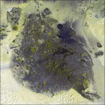
NASA Photo of Santa Clara Volcano and Pinacate Volcanic Fields
Ives Map of Santa Clara Volcano and Pinacate Volcanic Fields
The Pinacate After Kino
Ronald L. Ives
Between 1706 and 1882 there is no indisputable record of any visit to the Pinacates, although numerous Papago salt-gathering expeditions undoubtedly crossed the lavas on their traditional trail, worn into the volcanic glass by uncounted thousands of bare feet. It is possible that Francisco Garces, in October, 1771, stopped at Papago Tanks, on this old trail, during his transit of the desert between the mouth of the Colorado and Sonoyta, but the record is by no means clear. Indefinite legends, and the finding of bones and remnants of clothes by local Indians, indicate that emigrants passed near Papago Tanks some time between 1840 and 1870, perhaps in 1850, during the California gold rush, but further data are lacking.
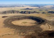
In 1882, Sr. Y. S. Bonillas, a mining engineer of Nogales, visited the Pinacates, and discovered one of the great calderas for which the region has since become famous.
The first extended exploration of the Pinacates in modern times was that of the MacDougal-Hornaday party of 1907. This study led to the construction of an accurate map by Godfrey Sykes, to a survey of the botanical and zoological features of the region, and to a quite definite verification of the findings of Kino, Salvatierra, and Manje. Members of this party also produced the first series of photographs of the craters and lava structures of the area.
Two years later, Cad Lumholtz, ably assisted by Alberto Celaya, spent some time in and near the Pinacate region, following, unknown to him, almost the same trails that Kino used more than two centuries before. From the notes collected by Lumholtz and [22] Celaya, the Kino itineraries were worked out by Bolton, and within the last decade, Lumholtz's map has been used in determining the route of the new railroad now under construction between Mexicali, Lower California, and Santa Ana, Sonora. Lumholtz's descriptions at times agree with those of Kino even to the descriptive analogies used."
Recent studies in the Pinacates, largely the work of the present writer, have produced no major new discoveries, but show quite plainly that the pioneer work of the expeditions headed by Kino was of a high order of accuracy ....
This identification of an extinct volcano in 1701 appears to be one of the first, if not the first, of such reports from North Amer ica, so far as can be determined from available literature, and antedates the publication of the works of Guettard and Desmarest, frequently called the pioneers of volcanology, by about half a century.
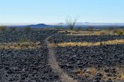
It seems somewhat ironic that Pinacate, first recognized extinct volcano in North America, will probably be among the last of such structures to be studied in detail; but in this desert region, where even the modern inventions of sheet-iron canteens and steel armored boots are of little avail against a malevolent and par simonious nature, many of those who cross the boundaries of the Pinacate country - the waterless, grave - lined Camino del Diablo; the desiccated and caliche-baked bed of the Sonoyta River; and the shifting, squeaking sands beside the unvisited red waters of the Gulf of California-heading toward the multicolored peaks rising like islands from "the sea of broken glass," cross them only once and are heard of no more.
Dr. Ronald L. Ives
The Discovery of the Pinacate Volcano
"Land of Lava, Ash, and Sand
The Pinacate Region of Northwestern Mexico" 1989
Originally published in
The Scientific Monthly
March 1942 Volume 54
Read Online
Carl Lumholtz
"New Trails in Mexico: An Account of One Year's Exploration in
North-Western Sonora, Mexico, and South-Western Arizona" 1912
For classic account of Sonora between west of Nogales and north of the Río de la Concepción, click
https://books.google.com/books/about/New_Trails_in_Mexico.html?id=FVx6AAAAMAAJ
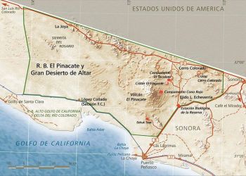
Road Map of Pinacate and Gran Desierto Biosphere Reserve
The Pinacate and Gran Desierto de Altar Biosphere Reserve
UNESCO's Man and Biosphere Designation
Sandy O'Hare
The Pinacate & Gran Desierto de Altar Biosphere Reserve is considered one of Mexico’s priority regions because it is immersed deep in the entrails of the Sonoran Desert, the most biodiverse desert in the world. It covers parts of California, Arizona, Baja California, Sonora and Sinaloa.
It is a magical place, with desolate beauty, unusual creatures, unique plants and notable geological characteristics. Part of the largest extension of mobile sand dunes in America (including the rare star shaped dunes) run right through the Reserve. The volcanic shield (500,000 Acres) is composed by 10 giant Maar type craters (the largest concentration in the world), more than 400 volcanoes, lava flows, lava tunnels and caves.
Although it is often thought that a desert is a life deprived place, the dark lava formations contrasting with the white sand dunes create multiple habitats with numerous biodiversity. You can find more than 560 species of vascular plants, 41 species of mammals, 200 species of birds, 43 species of reptiles, and amphibians and fresh water fish as well. Endemic, endangered, and threatened species exist in the Pinacate.
The Reserve is a vast heap of archeological remains that go back more than 20,000 years. It is an important cultural site for the Tohono O’odham people, who consider the Pinacate Mountain the place where the creation took place.
Because of all of this, the Mexican government, innumerable environmental groups, scientists, and the general public, decided to declare The Pinacate and Gran Desierto de Altar a Biosphere Reserve in June of 1993, with a surface of 1,765,706 Acres.
The Pinacate is part of the Man and Biosphere program of UNESCO since October of 1995, and a Ramsar Convention on Wetlands Site since September of 2007. It also forms part of an international brotherhood of biosphere reserves here in Sonora and Arizona.
The Schuk Toak (sacred mountain) visitor center is located only 20 minutes away from Rocky Point, you take highway 8 northbound towards Sonoyta, at kilometer 72 (10 miles from the old port) you will see a series of signs and the only paved road that takes you west into the desert.
After you make a left turn you will drive 4 miles alongside the Sierra Blanca, a granite structure 300,000,000 years old.
When you get to the visitor center, you must register and pay 50 pesos or 4.50 USD per person. Then the personnel will gladly address an opening lecture on the Reserve and on the existing activities both in English or Spanish. You will get to see a series of photographic exhibits, and in addition there is a display of the Pinacate’s collection of archeological remains. You will hike through a couple of short informative trails that describe the biological and geological aspects of the reserve. In the audiovisual room a short documentary by Mike Foster will be projected for you, also available in English or Spanish. You can enjoy the view from the terrace overlooking the Gran Desierto de Altar, or if you want, you can drive an extra 2 kilometers to the base of the first sand dune and hike until you see the Sea of Cortez from the top.
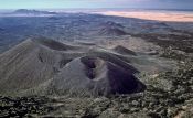
The vehicle route’s entrance is located on highway 8 halfway between Rocky Point and Sonoyta (half hour drive) at kilometer 52, once you pay at Schuk Toak visitor center there is no need to do so at the vehicle route, you do however need to register your car, and read the rules for this circuit. You don’t need a 4×4, or huge all terrain tires for this, although it is a dirt road, the employees often give maintenance to these paths so they won’t be as bumpy or loose as they would normally be. You will be given a map with the course and its places of interest. You can visit El Elegante Crater, with a mile in diameter and 700 feet deep, El Tecolote campground for a picnic, El Cono Mayo volcano with a trail that takes you to the top where you can see a panoramic view of the area, El Colorado Crater, ten informative vehicle stations and much more to see. You need from 2 to 4 hours to enjoy the vehicle route.
Another campground is El Cono Rojo, normally you register in the afternoon, you set up you camp, enjoy the star filled sky at night, and very early in the morning you hike your way to the Pinacate Peak (or Santa Clara Volcano) 4,000 feet high. It takes about 6 hours to get to the top where you can witness how Baja California unites with Sonora. It takes another 6 hours to get to Cono Rojo from the top. We recommend doing this particular activity in the fall to spring months, as the heat can get unbearable and potentially dangerous.
Sandy O'Hare
"The Pinacate Reserve:
The Rocky Point Times Newspaper
In Puerto Peñasco, Mexico
September 1, 2011
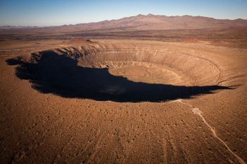
Elegante Crater with the Pinacate Volcano On the Horizon
The Discovery of the Pinacate Volcano
Ronald L. Ives
Histories of geology usually credit the recognition of extinct volcanoes far from present volcanic regions to Jean Guettard (1715- 1786) and Nicholas Desmarest (1725-1815), whose thorough studies of the ancient volcanoes of Auvergne have not only become scientific classics, but form the basis of the modern science of volcanology. A few of the more thorough works justly credit Strabo (63? B.C.- 21? A.D.) with the observation that Vesuvius, inactive at the time of his visit, was a volcano. [1]
Recent studies of manuscripts in the archives of Mexico, largely initiated by the work of Herbert E. Bolton, have disclosed three narrative accounts of an exploration of the Sonoran desert region in 1701, during which the Sierra de Santa Clara, now known as the Pinacate peaks, was correctly recognized as a formerly active volcano.
Since the beginning of the present century, the Pinacate region has been studied by workers in several fields of science, and the findings of this early expedition found quite accurate ....
The diaries of the three literate members of this expedition, all of which are literally "mines of information," did not come to |17| the attention of English-speaking scholars until about a generation ago, and only one of these has as yet been translated into English. Excerpts from these narratives constitute a fascinating "lost chapter" in the history of North American geology.
Eusebio Francisco Kino, S. J.
Born near Trent, Tyrol, August 10, 1645, Eusebio Francisco Kino, later to become the "Apostle to the Pimas," received his early education at Ala. After further study at Ingolstadt and Freiburg, he entered the Jesuit Order in 1665, taught grammar for three years, and became locally famous as a mathematician. In answer to a call for missionaries, Kino came to the New World in 1681 and labored for several years in Lower California. Assigned to Pimería Alta (now northern Sonora and southern Arizona) in 1687, he spent the remaining twenty-four years of his life Christianizing, exploring, and mapping that "so sadly watered vineyard of the Lord."
Chief among Kino's accomplishments are the rediscovery [2] that California was a part of the American mainland, and not an island; [3] the production, with crude instruments, of a satisfactory map of Pimería Alta; [4] and the exploration of a route from Sonoyta to the Gila, now known as the Camino del Diablo [5] and adequately marked by "three graves to the mile." Kino's terse narrative, condensed from Bolton's translation, follows:
"On the twentieth [of March, 1701], Palm Sunday, having said the two masses ... we set out for the west; and after covering six leagues of road, although level, and along weathered rocks like slag which long ago had been thrown out by this mountain or volcano of Santa Clara, which we passed on our right or to the north, we arrived at another tank of water shut in between rocks, [6] with very little pasturage; and ascending ... to a neighboring little hill, we descried California very plainly, to the west and southwest, and afterwards the soldiers also and all the men sighted it."
Juan María Salvatierra, S.J.
Contemporary, close friend, and often traveling companion of Kino, Juan María Salvatierra was born in Milan in November of 1644. After studies at Parma, Salvatierra became active as a Jesuit |19| missionary in Mexico in 1675 and was appointed visitador of Pimería in 1690. Instrumental in the founding of the mission at Loreto, Lower California, famous for its bells and pearls, Salvatierra, with the active cooperation of Kino, maintained the ecclesiastical settlement on the arid and poverty-stricken peninsula until his death, from age, illness, and over-exertion, in 1717.
Salvatierra's work is not as well known as Kino's, but the available records clearly show that his explorations, a part of his missionary activities as were Kino's, were of considerable scope and importance. Had Salvatierra been a less competent administrator, it is probable that his geographic contributions would have been greater.
Salvatierra's interesting narrative, translated from the printed Mexican version, [7] follows:
" ... and we left [San José de Ramos [8] ] guided by Indians who went after salt, giving us in more detail the trail to the sea.
On climbing a hill a league distant from San José de Ramos, on the flank of the hill of Santa Clara, we found a horrible country, which seemed more like cinders than land, and all of it scattered over with rocks and fragments, all black and shaped as pitch which has been spilled and run out and become solid. Thus in ancient times a horrible flow of volcanic material left the hill of Santa Clara, which has all the marks of having been a great volcano. It gave us more horror to discover eight leagues from here a great chain of mountains which seemed also to be made of cinders, so that I do not know where there is a place in which can be better shown the face of the earth in the general conflagration before judgment day .... "
Juan Mateo Manje
Guarding Kino and Salvatierra on several of their journeys into unknown lands was Captain Juan Mateo Manje, comandante of the presidio of Fronteras. His major literary work, "Luz de Tierra Incógnita," still untranslated, contains little direct biographical material, but indicates, by its style and context, that Manje was not only a keen observer, but was educated and well read. [9] In many instances, primitive customs, legends, and religious beliefs, usually unnoted by Kino and Salvatierra, are carefully described by Manje. |20|
Manje was a nephew of Domingo Jironza Petrez de Cruzat, governor of New Mexico (1680-1686 and 1689-1691). In 1693, Manje was appointed ensign in the newly formed Compañía Volante de Sonora, and rapidly advanced, being referred to as general in 1703. He was still commander of Fronteras in 1720, but apparently died before 1732, when Juan Bautista de Anza, Sr., father of the founder of San Francisco, took charge.
Manje's narrative, translated from the printed Mexican version, relates:
"On the twentieth [of March, 1701] we went toward the sea, with three Indian guides, traveling westward always over rocks and malpais [10] and crags and hummocks. We went eight leagues, coming to the shoulders of the peak of Santa Clara, where we halted at a place called El Tupo ... with scanty pasture and a natural tank of rain water, from which the horses drank, in a dry wash full of rocks and hummocks.
On these two trips [11] were seen hills and mountains and canyons of melted rocks, similar to the slags which leave silver when it is refined in a retort. This flux, which the Indians call temesquitate, [12] and cinders extend for many leagues from the vicinity of the aforementioned peak. We believe, and this seems probable, that this was a volcano, which lasted some years, and resulted from the concentration of a great combustible mass of sulfur and niter in an underground cavity. This was greatly ravaged, after which, lacking the store of material from which came the beginning of the fire of its formation, the voracity of the combustion ceased, and the materials became fused into this abundance of canyons, hills and mountains, ravaged as we have seen. It is probable that this lasted some centuries, as testify other volcanoes of Europe and those of the two Americas, whose subterranean fires, according to Padre Atanacio Quirquerio, [13] distinguished mathematical philosopher, have lasted four or five centuries, and at times the force and impetus of the materials have become so great that they have broken loose, and great rivers of fire have run out, as those of Vesuvius, and Etna or Mongivelo, [14]. In our own times there has flowed from the source a great river of fire, which ran with some speed to the sea, causing it to retire, and depositing, from this copiousness of melted material, a great plain of fragments in the gulf and [on the] sea bottom. [15] Thus appear to have come about the hills, mountains and valleys of melted rocks which we have seen. [They were] transformed from this flux which descended from the summit of Santa Clara |21| mountain, where can be seen a depth and profundity which cause terror and fright ….. " [16]
Verifications
Kino again visited the Pinacates in November of 1706, accompanied by Fray Manuel de la Oyuela y Velarde, Alférez Juan Matheo Ramírez, and Juan Antonio Durán. Leaving Durán, who was ill, at a water hole near the base of the peaks, the rest of the party climbed to the summit and verified Kino's previous observations regarding the peninsularity of California.
Between 1706 and 1882 there is no indisputable record of any visit to the Pinacates, although numerous Papago salt-gathering expeditions undoubtedly crossed the lavas on their traditional trail, worn into the volcanic glass by uncounted thousands of bare feet. It is possible that Francisco Garcés, in October, 1771, stopped at Papago Tanks, on this old trail, during his transit of the desert between the mouth of the Colorado and Sonoyta, but the record is by no means clear. Indefinite legends, and the finding of bones and remnants of clothes by local Indians, indicate that emigrants passed near Papago Tanks some time between 1840 and 1870, perhaps in 1850, during the California gold rush, but further data are lacking.
In 1882, Sr. Y. S. Bonillas, a mining engineer of Nogales, visited the Pinacates, and discovered one of the great calderas for which the region has since become famous.
The first extended exploration of the Pinacates in modern times was that of the MacDougal-Hornaday party of 1907. This study led to the construction of an accurate map by Godfrey Sykes, to a survey of the botanical and zoological features of the region, and to a quite definite verification of the findings of Kino, Salvatierra, and Manje. Members of this party also produced the first series of photographs of the craters and lava structures of the area.
Two years later, Carl Lumholtz, ably assisted by Alberto Celaya, spent some time in and near the Pinacate region, following, unknown to him, almost the same trails that Kino used more than two centuries before. From the notes collected by Lumholtz and [22] Celaya, the Kino itineraries were worked out by Bolton, and within the last decade, Lumholtz's map has been used in determining the route of the new railroad now under construction between Mexicali, Lower California, and Santa Ana, Sonora. Lumholtz's descriptions at times agree with those of Kino even to the descriptive analogies used. [17]
Recent studies in the Pinacates, largely the work of the present writer, have produced no major new discoveries, but show quite plainly that the pioneer work of the expeditions headed by Kino was of a high order of accuracy ....
This identification of an extinct volcano in 1701 appears to be one of the first, if not the first, of such reports from North America, so far as can be determined from available literature, and antedates the publication of the works of Guettard and Desmarest, frequently called the pioneers of volcanology, by about half a century.
It seems somewhat ironic that Pinacate, first recognized extinct volcano in North America, will probably be among the last of such structures to be studied in detail; but in this desert region, where even the modern inventions of sheet-iron canteens and steelarmored boots are of little avail against a malevolent and parsimonious nature, many of those who cross the boundaries of the Pinacate country - the waterless, grave-lined Camino del Diablo; the desiccated and caliche-baked bed of the Sonoyta River; and the shifting, squeaking sands beside the unvisited red waters of the Gulf of California - heading toward the multicolored peaks rising like islands from "the sea of broken glass," cross them only once and are heard of no more.
Dr. Ronald L. Ives
The Discovery of the Pinacate Volcano
"Land of Lava, Ash, and Sand
The Pinacate Region of Northwestern Mexico" 1989
Originally published in
The Scientific Monthly
March 1942 Volume 54