Reference Map & Timeline Links By Chapter
Best Book Guide
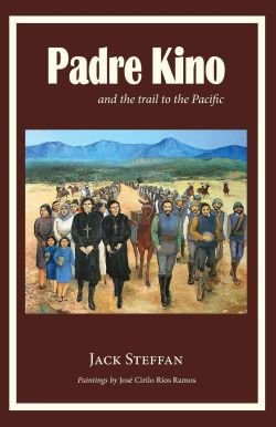
Padre Kino and the Trail to the Pacific
Padre Kino and the Trail to the Pacific
Latest Edition's Front Cover
Artist José Cirilos Ríos Ramos
Best Book Page Links
Best Book Reference - Maps & Timeline Links
Best Book Online - Chapter Table of Contents and Links to Each Chapter
Best Book Formats in English
Read Online and Download
To Read Online by Each Chapter With Maps, click
Best Book Reference - Links to Maps & Timelines by Chapter page
To Read Book by Each Chapter In PDF Format (original edition), click
Best Book Reference - Links to Maps & Timelines by Chapter page
To Read Online Entire Book in English, click
Best Book Entire Online English page
To Download Entire Book, click
Padre Kino and the Trail to the Pacific Entire Text document (text format)
Chapter Drawings
Chapter Links
Padre Kino and the Trail to the Pacific Online
Online Book Reference with Links to Maps & Timeline by Chapter
Best Book Reference - Maps & Timeline by Chapter
For Online Book Chapters, click
C0.2 Table of Contents
Cast of Characters
Maps by Chapters
Chapter Drawings
Click to go to
Best Book Guide Section Page
View Original Edition
In PDF Format
Best Book Chapter Links
Chapter Drawings
Book Guide Chapter Maps Instructions
Book Guide: Maps - Instructions
References Book Chapters and Pages
Page numbers refer to a specific map that is described and can be downloaded (click underline) below the page number reference and should be viewed when reading that page.General maps are usually at beginning of chapters and do not have page number references in line above.
The first digit refers to a chapter number. Maps drawn by or published from Kino maps have word "Kino" in file name. After downloading set "File View" menu to: "Icons - Large" for ease of previewing of maps before opening.
Click on Chapter and Map List document and download and print (2 pages).
Book Guide Chapters and Maps
Book Guide: Maps
Table of Contents (page 7)
Cast of Characters (page 8)
General Orientation Maps
0.1 Area Present (political & geographic map of present Arizona, Baja California & Sonora)
0.1 General Area_Present map
0.2 General Area Satellite" (view from space of above map - Pinacate volcanics east of Colorado River)
0.2 General Area_Satellite map
Chapter 1 - California Mission (1685)
1.1 Mexico Travels 1680 - 1711 (general map of Kino's travels in Mexico)
1.1_Mexico_Travels_1680-1711 map
For the map in high-density pixel screens (size 9 mb), click
https://repository.arizona.edu/handle/10150/623455
1.2 Gulf Travels 1683-85 (not shown: Kino-Guzman 1685 exploration of Tiburon Island & Baja coast)
1.2_Gulf Travels_1683-85 map
1.3 Baja Orientation 1683 - 1685" (area map for detail map below)
1.3_Baja_Orientation_1635-1685 map
Page 17
1.4 Across Baja Detail 1685 (shows detail of San Bruno area and Baja crossing route)
1.4_Across_Baja_Detail_1685 map
Page 17
1.5 Kino 'Descripcion Golfo' 1685
1.5 Descripcion Golfo 1685 map
Page 21
1.6 Kino 'Delineatio Nova' 1686
1.6 Kino 'Delineatio Nova" 1686 map
Chapter 2 - Indians Shall Not Be Slaves! (1685)
Page 27
2.1 Europe 1645 - 78" (Places in Kino's in life until age 40 when he became a missionary)
2.1_Europe_1645-78 map
Page 38
2.2 Pimería General (general location map of the Pimería Alta)
2.2_Pimeria_General map
Chapter 3 - Among the Pimas (1687)
3.1 Pimería Travels 1687 - 1711 (most complete map of Kino's travels in the Pimería Alta)
3.1_Pimeria_Travels_1687-1711 map
For the map in high-density pixel screens (size 12 mb), click
https://repository.arizona.edu/handle/10150/623457
3.2 Pimería Missions (list missions, visitas, villages and significant geographic features)
3.2_Pimeria_Missions map
Page 47
3.3 Tumacácori 1691 (first trip into present day Arizona)
3.3_Tumacacori_1691 map
Chapter 4 - The Young Lieutenant (1694)
Page 54
4.1 Gulf 1694 (second trip to Gulf of California; first with Manje)
4.1_Gulf_1694 map
Page 64
M 4.2 Boat 1694
4.2_Boat_1694
Page 70
4.3 O'odham Land 1694
4.3_O'odham_Land_1694 map
Chapter 5 The Blood of A Martyr (1694)
Page 72
5.1 San Pedro River to Gila River 1697
5.1_San_Pedro_River_1697 map
Chapter 6 - Vengeance! (1695) - No Maps
Chapter 7 - The Children Asked for Bread (1695)
Page 107
7.1 Kino Saeta's Death 1695
7.1_Kino_Saeta's_Death_1695 map
Chapter 8 - An Error in the Map (1698)
Page 116 - 121
Pinacate First from the Gila River across the O'Odham Desert 1698
Pinacate First Gila 1698 map
Page 122 - 123
8.2 Pinacate First Detail 1698
8.2_Pinacate_First Detail_1698 map
Page 122
8.3 Kino 'Teatro Trabajos' 1694 (map showing California may or may not be an island)
8.3_Kino Teatro_Trabajos_1696
For the map in high-density pixel screens (size 8 mb), click
https://repository.arizona.edu/handle/10150/623456
Chapter 9 - The Devil's Highway (1699)
Page 127
9.1 Colorado River via Devil's Highway 1699
Colorado_River_1698 map
Page 131
9.1 Colorado River via Devil's Highway 1699
Colorado_River_1698 map
Chapter 10 - Visit from Salvatierra(1701) (second visit, first Salvatierra visit at page 47)
Page 138
10.1 Pinacate Second 1701
10.1_Pinacate_Second_1701 map
Page 138
10.2 Pinacate Second Detail 1701
M_10.2_Second_Detail_1701.jpg map
Page 140
10.3 Kino 'Passo Tierra' 1701 (shows land connection to California)
10.3_Kino_Passo_Tierra_1701 map
Chapter 11 - Plan For New Spain (1705)
Page 156
11.1 Kino 'Nuevo Reyno' 1710" (found in Paris archives 4 years after book written)
11.1_Nueva_Reyno_1710 map
Page 157
11.2 Pinacate Final 1706 (last trip 4 years before death at age 66)
11.2_Pinacate_Final_1706 map
Chapter 12 - General Manje Writes A Report (1705)
Page 163
12.1 Sonoran Silver Mines 1640 - 1736
12.1_Sonora_Silver_Mines_1640-1736 map
Chapter 13 - The Chapel of St. Francis Xavier (1711) - no maps
Book Index
Summary, Author's Biography & Note
Timeline with Best Book Chapter & Map Links
In PDF and TEXT Formats
Timeline with Best Book Chapter & Map Links
"Padre Kino and the Trail to the Pacific"
Eusebio Francisco Kino, S.J. (1645 - 1711)
Chapter, page and map references to the Kino Book are underlined.
General maps are without page references.
10 Aug. 1645
Jesuit missionary Padre Eusebio Francisco Kino. S.J. (1645 - 1711) is born Eusebio Chini, the only son of Francesco and Margherita Chini, in the village of Segno. Segno is located in the foothills of the southern Alps and 15 miles north of the historic city of Trent in present day Italy.
24 Oct. 1648
The Thirty Years War in Europe ends.
20 Nov. 1665
Joins the Jesuit order as a novice and for the next 12 years prepares for the priesthood. Kino studies and teaches mathematics, astronomy and other natural sciences at the universities of Landsberg, Freiburg, Ingolstadt and Hall am Inn in present day Germany and Austria.
Before joining the Jesuits, Kino suffers from an illness that brings him close to death. He vows he will become a missionary if his patron saint, Francis Xavier, intercedes by sparing his life. St. Francis Xavier (1506–1552) was a co-founder of the Jesuits and was its pioneering missionary to Asia. He ministered for 10 years in India and then worked in the East Indies and Japan and died as he was traveling to China. He was canonized as a saint in 1622.
11 Jun. 1677
Ordained a Roman Catholic priest in Ottingen (Altottingen) in present day Germany. Kino continues his pastoral ministry and teaching.
May 1678 to Jan. 1681
After 8 years of petitioning his Jesuit superiors, Kino is granted permission to become a missionary. Kino sails to Southern Spain with 18 other Jesuit missionaries. Waits two years for passage across the Atlantic to Mexico. In Seville and Cádiz Kino works as a parish priest and teaches mathematics and natural sciences at nearby universities. Further supports himself by making astronomical and nautical instruments.
10 Aug. 1680
Beginning of the Pueblo Revolt. Allied Native peoples expel Spanish settlers from their 80 year old colony in New Mexico. Colony reestablished 14 years later by military force.
Jun. 1681
Arrives in Mexico City and writes one of the first astronomical treatises published in the New World on a large comet visible worldwide. Kino precisely maps the 7 month course of the comet,
28 Oct. 1682
Appointed royal cartographer, surveyor and missionary to the Atondo Expedition - a venture by the Spanish King to colonize Baja California. Last major settlement efforts were privately funded by conquistadors Herán Cortez and Francisco Coronado in mid 1500s.
4 Apr. 1683
Atondo Expedition sails across the Gulf of California and establishes a settlement on the coast of La Paz Bay but abandons it after three months and sails back to the Mexican mainland.
Table of Contents
Table of Contents page
Table of Contents document (pdf)
Cast of Characters
Cast of Characters page
Cast Of Characters document (pdf)
Map 0.1 Area - Present (political & geographic map of present Arizona, Baja California & Sonora)
Area Present map
Map 0.2 Area - Satellite (view of above map - Pinacate volcanics east of Colorado River delta)
Area Satellite map
Chapter 1 - California Mission (1685)
California Mission page
California Mission document (pdf)
Map 1.1 Mexico Travels 1680 - 1711 (general map of Kino's travels in Mexico)
Mexico Travels map
For the map in high-density pixel screens (size 9 mb), click
https://repository.arizona.edu/handle/10150/623455
Map 1.2 Gulf Travels 1683 - 85 (not shown: Kino-Guzman 1685 exploration of Tiburon & Baja coast)
Lower Gulf Travels map
Map 1.3 Area - Baja Orientation 1683 - 1685 (shows location of next detail map below)
Area Baja map
6 Oct. 1683
Atondo Expedition returns to Baja California and establishes a settlement at San Bruno on Gulf coast (near present day Loreto) where Kino ministers to Native people, builds his first mission and explores.
Pages 1 - 27
Page 17: Map 1.4 Across Baja - Detail 1685 (shows detail of San Bruno area and Baja crossing route)
Across Baja map
Page 17: Map 1.5 Kino 'Descripcion Golfo' 1685
Kino Gulf map
Page 21: Map 1.6 Kino 'Delineatio Nova' 1686
Kino Delineatio Nova map
Page 27: Map 2.1 Europe 1645 - 78 (important places in Kino's life before he becomes a missionary)
Europe map
15 Aug. 1684
Takes final Jesuit vow at San Bruno at age 39.
Jan. 1685
Makes overland crossing of Baja California to Pacific Ocean with members of the Atondo Expedition - first Europeans to make overland journey. Kino sees blue abalone shells along the Pacific coast.
8 May 1685
Atondo Expedition stricken by scurvy and lack of supplies abandons Baja California and sails back to Mexico mainland.
Chapter 2 - Indians Shall Not Be Slaves! (1685)
Indians Shall Not Be Slaves page
Indians Shall Not Be Slaves document (pdf)
Jun. to Aug. 1685
Kino and Captain Guzman sail northward in Gulf of California exploring for new mission sites along the Baja coast. Their ship is anchored for six weeks near Tiburon Island waiting for favorable winds to continue sailing. During the six weeks Kino visits and ministers to the Seri people.
Tiburon [add link]
Jan 1986
Returns to Mexico City and advocates for new expedition to Baja California to continue his missionary activities. Spanish officials in Mexico City support Kino's plan.
19 Jun. 1686
Learns that Spanish King will not support new expedition to Baja California. Funds in Mexico must be sent to Spain to pay for accidental sinking of French ship. Kino assigned as missionary to Seri people.
Pages 28 - 29
16 Dec. 1986
Appears before the high court of Royal Audiencia in Guadalajara requesting that judges suspend for 5 years the system of repartimiento where Native people are forced to work in Spanish silver mines and ranches. Learns during the hearing that the judges recently received a decree from the Spanish King suspending the system of repartimiento for 20 years.
Pages 31 - 33
13 Mar. 1687
Assigned as missionary to the Pima people and establishes his mission headquarters at Dolores. Next day from Dolores Kino begins his regular 70 mile circuit to villages at San Ignacio, Imuris, Remedios. Later in the month Kino travels with 100 Pimas to Tuape to celebrate Easter with Spanish settlers.
Map 3.1 Pimería Travels 1687 - 1711 (most complete map of Kino's travels in the Pimería Alta)
Pimeria Travels map
For the map in high-density pixel screens (size 12 mb), click
https://repository.arizona.edu/handle/10150/623457
Map 3.2 Pimería Missions (map of missions, visitas, villages and significant geographic features)
Pimeria Missions map
Kino introduces horses, cattle and other herd animals and winter wheat and other European cultivars to the Native people that he encounters during his 24 years in the Pimería Alta (present day Northern Sonora and Southern Arizona.) The Jesuit missionary effort in Sonora and Arizona is one of its most successful in the New World despite its close proximity to Spanish settlements in northeastern Sonora.
Pages 34 - 37
Page 38: Map 2.2 Area - Pimería Alta (location map of the Pimería Alta)
Area Pimeria map
Chapter 3 - Among the Pimas (1687)
Among the Pimas page
Among the Pimas document (pdf)
2 May 1687
Travels over 40 miles from Dolores with Pima leaders to the Spanish mining center of Bacanuche to have government officials formally acknowledged to settlers the enforcement of the Spanish King's order prohibiting the system of repartimiento.
Page 43
25 Jul. 1688
At Native village of Mototicachi, 100 miles northeast of Dolores, a Spanish officer orders the killing of all the 50 adult males and imprisons all women and children of the village as slaves. Officer acts on unjustified rumors that village leaders were part of a conspiracy by the Native peoples throughout Northern Mexico to revolt against the Spanish. The officer is sentenced to death but escapes. Although outside his area of responsibility, Kino seeks justice for the wronged Native people of Mototicachi.
Page 40 - 42
2 Apr. 1690
Jesuit missionaries are expelled from their missions in the Sierra Madre mountains during the 2 year Tarahumara Revolt. Two missionaries are killed. The revolt occurs 150 miles southeast of the Dolores.
Page 46
1691
Jan. 1691
First visit to present day Arizona. After an invitation by Sobaípuris (Santa Cruz and San Pedro River Pimas), Kino and Father Salvatierra travel to the village of Tumacácori near present day Tumacácori National Historic Park. Kino is invited by leaders of Bac to visit their village south of Tucson.
Pages 46 - 50
Page 47: Map 3.3 Tumacácori 1691 (first trip into present day Arizona)
Tumacacori map
18 Jul 1691
The Flying Company ("Compañía Volante") established with 30 soldiers as a roving Spanish military unit instead of a unit stationed at a presidio. The Flying Company responds to increasing attacks on the Spanish settlers of Sonora by the Apaches and their Native allies (Suma, Jocome and Janos tribes).
23 Aug. 1692
First Northern Exploration. Visits village of Bac and names the Bac visita (mission station) after his patron saint, Francis Xavier. Kino returns to Dolores by traveling across the desert to present day Benson and continuing south up the San Pedro River. The Northern Explorations along the Santa Cruz and San Pedro Rivers to their junctions with the Gila River occur from 1694 to 1699.
Page 51
Chapter 4 - The Young Lieutenant (1694)
The Young Lieutenant page
The Young Lieutenant document (pdf)
26 April 1693
Native and Spanish people living throughout present day northern Sonora and southern Arizona travel to Dolores to celebrate the consecration of Kino's mission church.
11 Dec. 1693
First Altar Desert Exploration. Travels to the eastern coast of the Gulf of California and climbs Nazareno Peak and sees mountains in Baja California across the Gulf waters. Establishes a mission station at Caborca.
23 Feb. 1694
Second Altar Desert Exploration. Travels with Lieutenant Juan Mateo Manje and begins construction of a ship in the desert near Caborca to supply the yet to be restarted missions in Baja California. Kino brings about a peace settlement between two Western Pima leaders. Two other 1694 explorations are made with Manje into the Altar Desert.
Pages 54 - 71
Page 54: Map 4.1 Gulf 1694 (first trip to Gulf of California with Manje)
East Gulf 1st map
Page 64: Map 4.2 Boat 1694
East Gulf 2nd Map [add link]
Page 70: Map 4.3 O'dham Land 1694
West O'odham map
21 Oct. 1694
Jesuit Father Francisco Javier Saeta arrives in Caborca as its first resident missionary priest.
Nov. 1694
Second Northern Exploration. Explores Santa Cruz River north of Bac to its junction with the Gila River. Kino is the first European to visit villages in the Tucson Valley and to see the Casa Grande at Casa Grande Ruins National Monument.
Page 72
Page 72: Map 5.1 San Pedro River 1697
San Pedro River
Chapter 5 - The Blood of A Martyr (1694)
The Blood of a Martyr page
The Blood of a Martyr document (pdf)
2 Apr. 1695
Father Saeta martyred in his mission church at Caborca on Easter morning during the early hours of the Tubatama Uprising. Kino tries to reestablish peace between Spanish and Western Pimas.
Pages 73 - 84
Chapter 6 - Vengeance! (1695)
Vengeance! page
Vengeance! document (pdf)
9 June 1695
Calls peace conference at El Tupo. Spanish military betrays Pimas and kills 30 unarmed and innocent Pimas who are unable to escape. Uprising continues and nearby missions are destroyed by Western Pimas. Kino and his mission headquarters at Dolores are spared.
Page 85 - 96
30 Aug. 1695
Calls another peace conference at El Tupo and peace settlement is made between the Pimas and Spanish. Peace lasts for the next 55 years until the start in Tubatama of the Pima Uprising of 1751.
Pages 97 - 99
Chapter 7 - The Children Asked for Bread (1695)
The Children Ask For Bread page
The Children Asked For Bread document (pdf)
16 Nov. 1695 to May 1696
Travels to Mexico City to quash false rumors about the Tubatama Uprising. Before his Jesuit superiors argues against being withdrawn as a missionary and reassigned as a university professor. Before the highest Spanish officials in Mexico, Kino petitions to restart missionary efforts in Baja California and to restore lands to Native People of Mototicachi. During the 2 months before his trip, Kino writes biography of Father Saeta. In biography is a description of Kino's missionary methods that are precursors to today's methods. Also draws map ("Saeta's Death") that accompanies biography.
Pages 100 - 109
Page 107: Map 7.1 Kino "Saeta's Death" 1695
Kino Saeta map
May 1696
On his return trip from Mexico City, Kino narrowly escapes death when he takes side trip to Baserac to meet his Jesuit superiors after leaving his military escort who are all killed the next day in a Jocome attack. After arriving in Dolores, Native leaders living throughout the Pimería meet with Kino.
Jul. 1697
Kino's new assignment to restart missions in Baja California revoked after Spanish civilian and military officials petition Kino's superiors to have him remain in Pimería Alta to maintain peace.
6 Oct 1697
Meets with Native leaders at Dolores and travels with them more than 100 miles to Baserac to request more missionaries from Kino's Jesuit superior.
10 Oct 1697
ather Salvatierra restarts Kino's Baja California missionary efforts at Loreto near site of San Bruno without assistance from Spanish King. Jesuits are granted secular governmental authority. Contributions by Kino's missions in Sonora and by donors to the Pious Fund maintain Salvatierra.
Pages 112 - 113
Nov. to Dec. 1697
Third Northern Exploration. Explores all of the San Pedro River to its junction with Gila near present day Winkelman and follows Gila to Casa Grande Ruins. Returns by Santa Cruz River. Kino brings about peace settlement between two Sobaípuri leaders near Arivaipa.
25 Feb. 1698
Apaches and their allies attack and destroy the mission at Cocóspera.
30 Mar. 1698
Sobaípuris led by Chief Coro defeat Apaches and their allies who attack village near Quiburi and present day ghost town of Fairbank. Kino continues to make series of visits to Sobaípuri villages in the upper San Pedro and Santa Cruz river valleys.
Page 111
Chapter 8 - An Error in the Map (1698)
An Error in the Map page
An Error in the Map document (pdf)
22 Sep. 1698
Fourth Northern Exploration. Travels to Gila River near Casa Grande and treks southwest over the desert lands of the O'odham (Desert Pima) to the Pinacate volcanic field immediately north of present day Puerto Penasco. From Pinacate Peak Kino believes he sees the head of the Gulf of California.
Pages 116 - 124 Pinacate First across O'odham Desert Lands
Pinacate 1st via O'odham map
Page 122 - 123: Map 8.2 Pinacate First Detail 1669
Pinacate 1st Detail map
Page 122: Map 8.3 Kino 'Teatro Trabajos' 1694 (map showing California might be an island)
Kino Teatro Trabajos
For the map in high-density pixel screens (size 8 mb), click
https://repository.arizona.edu/handle/10150/623456
Chapter 9 - The Devil's Highway (1699)
The Devil's Highway page
The Devil's Highway document (pdf)
7 Feb. 1699
First Colorado River Exploration. Travels the desolate Camino del Diablo ("Devil's Highway”) and ends the exploration just short of the Gila River's junction with the Colorado River. Manje sees the junction from a mountain peak. Returns by visiting villages on the Gila River and Santa Cruz Rivers. Kino's Colorado River Explorations occur from 1699 to 1701.
Pages 125 - 134
Page 127: Map 9.1 Colorado River 1699
Colorado River map
20 Mar. 1700
Receives a gift of a wooden cross strung with 20 blue abalone shells delivered at Remedios from the Cocomaricopas living on the Gila River just east of its junction with the Colorado River.
Apr. to May 1700
Halts planned trip to Colorado River at Bac. Begins construction of the first church of Mission San Xavier del Bac. Calls "Blue Shell Conference” and the Native leaders living throughout Pimería Alta meet at Bac and confirm that a land passage to California is possible based on the overland trade of blue abalone shells. On return trip Kino rides 75 miles in less than 24 hours to San Ignacio to save Native man from execution. Back at Dolores, Kino splits herd and sends 700 head of cattle to Bac. His Jesuit superiors grant Kino permission to move his mission headquarters from Dolores to Bac but his replacement at Dolores never arrives.
See attached book excerpts "The Blue Shell at Mission San Xavier del Bac"
from "Kino: A Legacy" by Charles Polzer, S.J. (pages 68 - 70)
San Xavier Blue Shell Polzer document (pdf)
and from "On the Trail with Padre Kino" by Professor Frank Lockwood (pages 82 - 86 and pages 133 - 138)
San Xavier Blue Shell Lockwood document (pdf)
Sep. 1700
Second Colorado River Exploration. Travels via Camino del Diablo and meets Native peoples living on the Lower Colorado River near present day Yuma. From a mountain peak looks south and sees the Colorado Delta and the head of the Gulf of California.
Pages 135 - 137
1701
War of Spanish Succession begins in Europe. Spanish King diverts funds for additional missionaries to pay for war against powers who oppose the unification of France and Spain under the Bourbon kings.
Chapter 10 - Visit from Salvatierra (1701)
Visit from Salvatierra page
Visit From Salvatierra document (pdf)
1701
Kino draws his map "Passo por Tierra" showing land passage to California.
Page 140
Page 140: Map 10.3 Kino 'Passo Tierra' 1701 (shows land connection to California)
Kino Passo Tierra map
Feb. 1701
Third Colorado River Exploration. Unsuccessful attempt to reach Colorado River delta by traveling in the Gran Desierto along waterless Gulf coast. Kino and Salvatierra climb Pinacate Peak and see clearly the head of the Gulf of California.
Pages 138 - 140
Page 138: Map 10.1 Pinacate Second 1701
Pinacate 2nd map
Page 138: Map 10.2 Pinacate Second - Detail 1701
Pinacate 2nd Detail Map [add link]
3 Nov. 1701
Fourth Colorado River Exploration. Travels via Camino del Diablo and crosses Colorado River on a raft to present day state of California. Kino urges that peace be made among the waring Yuma, Quíquima, Cugane, Hogiopa (Cocopah) and Pima tribes. Kino organizes food relief from the Quíquimas to the needy Yumas whose crops had failed.
11 Mar. 1702
Fifth Colorado River Exploration. Travels south of Colorado River delta into northern most Baja California. Sees sun rising over Gulf of California toward the mainland of Mexico - proof that California is not an island and that a land passage exists. Fellow explorer Father Manuel González dies on return trip.
Page 140 - 142
Chapter 11 - Plan For New Spain (1705)
Plan for New Spain page
Plan for New Spain document (pdf)
1703 - 1711
Jesuit superiors do not grant Kino permission to make further explorations to the Colorado River. Kino builds churches at missions in present day Sonora. Native people from present day Arizona especially from the village of Bac travel into Sonora to help Kino.
Pages 142 - 143
Jan. 1704
Consecrates newly built churches at Cocóspera and Remedios.
2 Apr. 1704
Opens shorter cattle trail to Guaymas - new supply port for Salvatierra's missions in Baja California.
Jan. to Mar. 1705
The lieutenant commander from Fronteras coerces 90 villagers to leave Dolores, angers Native leaders and spreads false rumor among Spanish officials about possible Pima rebellion. Kino prevents violent Spanish military reaction to rumors. The "indiscreet lieutenant" is later dismissed.
Pages 146 - 153
21 Jan. 1706
Discovers Tiburon Island is not attached to mainland. Kino advocates for a shorter sea route to Baja California by the Gulf islands near Kino Bay. Restarts construction of ship in the desert near Caborca.
1706
Begins major church construction at missions at Magdalena, Tubatama, Sáric, Pitiquito and Caborca.
22 Oct. 1706
Travels to Pinacate Peak along with a governmental officials who witness that Baja California is connected to the mainland and not an island. Kino's last exploration at age 62.
Page 157
Page 157: Map 11.2 Pinacate Final 1706 (last trip 4 years before death at age 66)
Chapter 12 - General Manje Writes A Report (1705)
General Manje Writes A Report page
General Manje Writes a Report document (pdf)
3 Dec. 1706
Former Kino trail companion Juan Mateo Manje, now General Manje, completes his history of Sonora entitled "Light on the Unknown Lands of North America". Last chapter contains recommendations that are critical of Jesuit mission policies. Manje incorporates recommendations into a petition signed by other Spanish miners and ranchers that is widely distributed to religious and civil authorities asking that mission lands be reduced and the system of repartimiento (forced Native labor) be reintroduced.
Pages 158 - 164
Page 163: Map 12.1 Sonoran Silver Mines 1640 - 1736
21 Jan. 1708
Jesuit superiors complain to civil authorities about Manje's petition and Manje is arrested and jailed in Parral, Chihuahua until March 11, 1708.
Pages 165 - 167
27 April 1708.
Manje rejailed but released after Jesuit intervention.
Pages 168 - 169
Chapter 13 - The Chapel of St. Francis Xavier (1711)
The Chapel of St. Francis Xavier page
The Chapel of St. Francis Xavier document (pdf)
1710
Completes writing last part of 11 year series of reports to the Spanish King containing Kino's history of his missionary activities and his recommendations for future programs. Collected series of reports are commonly referred to as "Favores Celestiales" (Heavenly Favors) or "Kino's Historical Memoirs."
Pages 153 - 156 and Page 170
1710
Draws his map "Nuevo Reyno". Map accurately shows rivers and villages in the present day states of Arizona, New Mexico, Baja California, Sonora, Chihuahua, Sinaloa and Durango. This map was discovered in archives in Paris archives in 1964.
Page 156
Page 156: Map 11.1 Kino 'Nuevo Reyno' 1710" (found in Paris archives 4 years after book written)
Kino Nueva Reyno map
15 Mar. 1711
Travels to present day Magdalena and collapses during the Mass dedicating a chapel to his patron saint, Francis Xavier, and several hours later Kino dies peacefully near midnight at the age of 66.
Page 173 - 176
Mar 1711
Chief Coro dies in Apache attack on his home at Quiburi near present day ghost town of Fairbank.
Page 176 - 177
Book Index
Book Index page
Book Index document (pdf)
End of Book
(See attached excerpt "Kino Decisive Years" from "Cycles of Conquest" by Professor Edward H. Spicer (pages 314 - 318)
Spicer Kino Decisive Years document (text)
Spicer Kino Decisive Years document (pdf)
1767
Jesuits expelled from the New World and Franciscans take over missionary work in the Pimería Alta.
1700 - 1800s
Kino's maps or maps based on his cartography are extensively published in Europe including the publication of Kino's 1701 map "Paso por Tierra" by the English Royal Society in 1731.
1919
Dr. Herbert E. Bolton translates Kino’s "Favores Celestiales". Dr. Bolton, head of the Bancroft Library and Dept. of History, University of California (Berkeley0, is the father of the study of Spanish Colonial history in the United States.
1936
Dr. Bolton's 640 paged Kino biography entitled "The Rim of Christendom "is published.
14 Feb. 1965
Kino statue unveiled at an international ceremony in the Hall of Heroes in United States Capitol Rotunda as the State of Arizona's heroic representative to the people of the United States.
21 May 1966
Kino's skeletal remains found in Magdalena by a team of international researchers.
2 May 1971
Newly constructed town plaza and mausoleum in Magdalena dedicated by Mexico's President Luis Echeverría and the town is renamed Magdalena de Kino. Two century old annual fall pilgrimage to Magdalena continues in homage to Padre Kino and his patron saint, Francis Xavier.
1979
Artist Ettore "Ted" DeGrazia publishes "DeGrazia and Padre Kino" that contains DeGrazia's paintings and writings on Kino.
7 Feb. 1998
The Vatican, the government of the Roman Catholic Church, grants permission to open the investigation of the cause for Kino's sainthood.
25 May 1971
The Archdiocese of Hermosillo begins the local diocesan process for the cause for Kino's sainthood. First step is passed and Kino is named "Servant of God" by the Roman Catholic Church because his life exemplifies the practice of the Christian heroic virtues.
1988
Dedication in Tucson of first of three “Padre on Horseback” statues. Other two replicas later dedicated in Magdalena de Kino and Segno, Italy. Major Kino statutes previously dedicated are displayed in Washington, D.C., Trent, Tucson, Phoenix, Hermosillo, Nogales and Tijuana.
4 May 2006
The Vatican accepts delivery of 130 pounds of documents for consideration of Kino's cause for sainthood.
2010
The Vatican approves the preparation of the "positio" - the petition for sainthood and supporting historical documents for consideration by the Congregation for the Causes of Saints. If the positio is approved by the Congregation's theologians and the Pope, Kino will pass the second step and be named "Venerable". Two miracles through Kino's intercession will then be required to be verified by the Vatican before Kino is named a saint by the Roman Catholic Church.
10 Mar 2010
The State of Sonora accepts a 4 volume Kino biography written by Professor Gabriel Gómez Padilla. The writing and publishing of the Kino biography is funded by the Mexican federal government in recognition of Kino's historic and cultural contributions to the nation of Mexico.
2011
State of Sonora requires that all of its governmental documents must contain stamp "Year of Kino" in commemoration of the 300th anniversary of Kino's death. Extensive celebrations are held in United States, Mexico and Italy. Vatican issues postal stamp honoring Kino.