Kino Explorer
Sonora and Arizona
Chronology, Routes and Maps
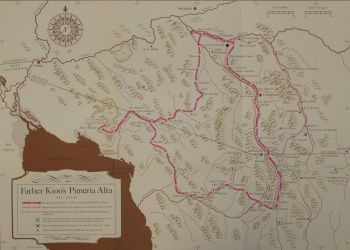
Page Notes: Expedition Number in last line of each journey entry refers to exploration numbered in the map legend of the "Pima Land" map.
To see map legend, click Explorer Section Page and scroll down below "Pima Land" map. Detailed maps are embedded in exploration chronology below for many expeditions.
Trip Letter or Number in last line of Expeditions 23 through 29 refer journey entries identified in detailed narrative of Kino's trips to find land route to Baja. For detailes click Explore Colorado River and Delta page.
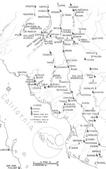
El Camino Real Occidental
Mexico City, Alamos and Huépac
1686 - 1687
November 20, 1686 - March 13, 1687
Begins his 24 years of work in the Pimería Alta. Leaves Mexico City on November 20, 1686 and via El Camino Real Occidental arrives at end of the El Camino Real at Huepac. Kino accepts the invitation of O'odham living in village of Cosari and establshes his mission headquarters that he names after Nuestra Señora de los Dolores.
Padre Kino
Route: El Camino Real Occidental (dotted line on map): Mexico City, Leon, Guadalajara, Compostela, Fuerte, Los Frayes (Alamos), Tónichi, Conicari, and Huépac (Guepaca). Then travels to Oposura (now Montezuma), Real de San Juan, Huépac (Guepaca), Opodepe, Tuape, Cucurpe and Cosari (Dolores).
Kino again travels the El Camino Real Occidental to Mexico City from Mission Dolores on November 16, 1697 to January 8 to appear before the highest officials of New Spain to secure peace in the Pimería Alta, to prevent the missions from closing and to advocate for the Jesuit return to Baja. Kino's return trip from Mexico City begins on February 8, 1696 and he arrives in Dolores in mid May, 1696 via the El Camino Real Occidental. See trips descriptiion for 1697 to 1698 below.
Kino's Early Missions
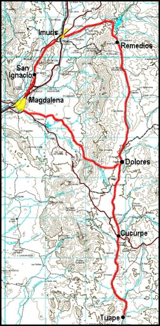
Dolores, Magdalena, San Ignacio, Imuris and Remedios
1687
March 13, 1687
To Dolores
Kino's Entrada into the Pimería Alta
Founding of Kino's headquarter mission
Padres Kino, Gonzalez, Burgos and Aguilar
Route: Oposura, Real de San Juan, Valle de Sonora (Guepaca Mission), Opodepe, Tuape, Cucurpe, Nuestra Senora de los Dolores. Return Remedios, Imuris, San Ignacio.
Expedition 01
March, 1687
Kino's Early Missions
After founding Dolores, makes first of many visits to new mission sites.
Circuit is 60 miles or 100 kilometers
Padres Kino and Aguilar
Route: Dolores, Magdalena, San Ignacio del Caborica, San Jose de Imuris, Nuestra Senora de los Remedios, Dolores
Expedtion 02
April, 1687
Same journey as above repeated
May, 1687
Kino presents cedula banning slavery to colonial authorities
To Real (Town) de Bacanuche
Kino
Expedition 03
1689
January, 1689
To Cocospera
Padres Kino and Gonzalez
Route: Dolores, Remedios, Babasaqui, Santiago de Cocospera Return by the same route
Expedition 04
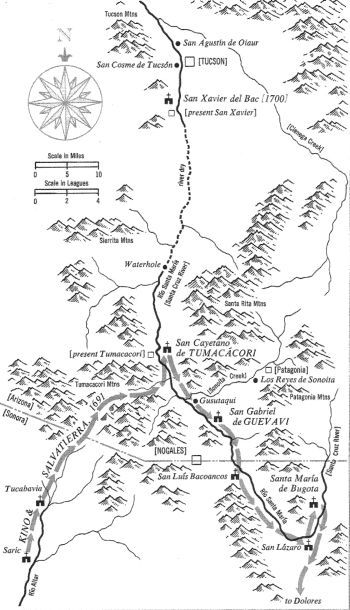
To Tubutama and to Tumacácori
Kino's First Major Exploration and Trip Into Arizona
1691
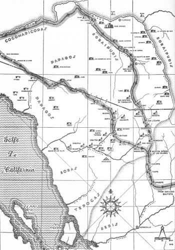
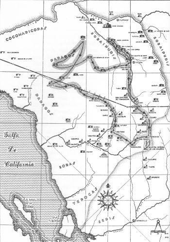
January-February, 1691 (See above Map)
To Tubutama and Tumacacori
First major exploration of the Pimeria Alta and first trip into Arizona. Kino names the native village and later mission at Tumacacori after chruch reformer and patron of wheat San Cajetano (St. Cajetan). During the trip Kino persuades Salvatierra that Jesuit misisons should return to Baja.
Padres Kino and Salvatierra
Route: Dolores, Remedios, Imuris, San Ignacio, Magdalena, San Miguel del Tupo, San Pedro del Tubutama, EI Saric, San Ambrosio del Busanic, Tucubavia, San Cayetano del Tumacacori, San Gabriel de Guevavi, San Luis Bacoancos, San Lazaro, Cocospera, Remedios, Dolores
Exploration 05
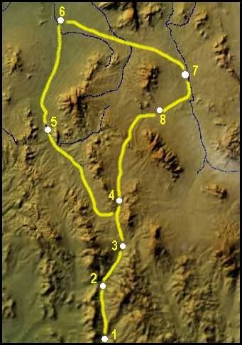
San Xavier del Bac, Tucson, San Pedro River and Quiburi
1692
August-September
To San Xavier del Bac and Quiburi
Visit Sobaipuiris in Santa Cruz and San Pedro river valleys.
Kino
Route: Dolores, Remedios, Cocospera, San Lazaro, Bacoancos, Guevavi, Tumacacori San Xavier del Bac, Tucson, San Salvador de Bai-cat-can, Santa Ana de Quiburi (Fairbank), Santa Cruz de Gaibanipitea, San Joaquin de Basosucan (Huachuca), Santa Maria de Bugota, Cocospera, Remedios, Dolores
Expedition 06
Dolores (1), Remedios (2), Cocóspera (3), Santa María (4), Tumacácori (5), Bac (6), Quíburi (7), Huachuca (8) and return Santa María (4), Cocóspera (3), Remedios (2), Dolores (1).
1693
December 11-18, 1693
To Caborca and the Sierra del Nazarene
Visit Sobas of Lower Altar Valley
First view toward head of the Gulf of California from mainland Mexico from Nazerene summit.
Padres Kino and Campos, and Captain Romero
Route: Dolores, Magdalena, El Tupo, El Bosna, Tubutama, Santa Teresa, San Antonio de Oquitoa, Altar, San Diego Pitquin, La Concepcion del Caborca, Sierra del Nazareno Return by the same route
Expedition 07
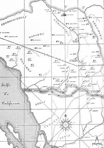
To Caborca, Nazareno Mountain Summit and Gulf of California Coast
Return by Trincheras to Dolores
1694
February 7-23, 1694
To Caborca and the Gulf of California coast
23 days, 375 miles, average 16 miles/day, 950 native people counted
Padres Kino and Kappus, and Captain Manje
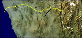
Route: Dolores, Magdalena, El Tupo, El Bosna, Laguna, El Comac, Pitquin, Caborca, Sierra del Nazarene, mouth of Rio Altar Return by the same route to Pitquin, thence along Rio de San Ignacio (or Magdalena), to Magdalena and Dolores
Expedition 08
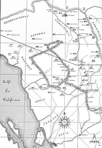
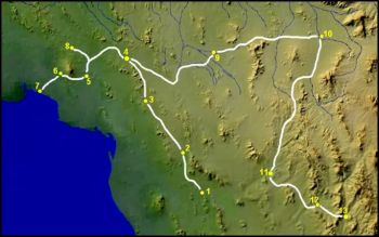
Dolores (1), Magdalena (4), El Tupo (5), El Ocuca (6), Pitiquito (El Pitiquín) (7), Caborca (8), El Nazareno Mountain Summit (9), El Desemboque (10). The route in black marks the return route by Trincheras (11) to Dolores. The route in white marks the trip just before from Dolores to San Juan [Banamichi] (3) trhough Opodepe (2) to meet General Domingo Jironza and his nephew lieutenant Juan Mateo Manje.
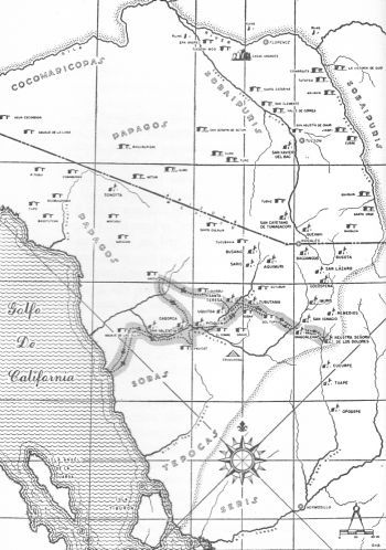
To Bacpia, Caborca and Kino Begins Building Ship
Manje to Gulf of California Coast
1694
March 16-April 4, 1694 (See Map Above)
To Bacpia, Caborca and Gulf of California coast
Kino starts building a ship in the desert to cross the Gulf of California if Jesuit missions return.
19 days, 550 miles, average 29 miles/day, 980 native people counted
Kino and Manje
Route: Dolores, Magdalena, El Tupo, El Bosna, Tubutama, Santa Teresa, Oquitoa, Altar, Quisoli, San Eduardo de Bacpia, Caborca
Manje on alone to Unuicat, Sierra del Nazareno and coast at Santa Sabina (Port Lobes) Return via Tubutama and Magdalena to Dolores
Expedtion 09
To Caborca, Kino Continues Building Ship
Manje through O'odham Land to North
1694
June 6-26, 1694 (See Map Above)
Kino to Caborca
Manje through O'odham Lands to Cups, Moicaqui and Caborca
20 days, 525 miles, average 26 miles/day, 900 native people counted
Kino and Manje together from Dolores to Tubutama, via Magdalena Kino thence direct to Caborca to continue ship building
Manje through O'odham Land: Saric, Busanic, Tucubavia, San Estanislao del Ootcam (Gubo Verde), Santa Eulalia, San Vicente, Cups, San Luis Bertrando del Bacapa (Moicaqui), Bacpia, Caborca Return to Dolores by Tubutama and San Ignacio Manje left ill at San Ignacio
Expedition 10
October, 1694
To Caborca
Installation of Padre Saeta at Caborca
Padres Kino and Saeta
Route: Dolores, Magdalena, El Tupo, Laguna, El Comac, Pitquin, Caborca
Expedition 11
November, 1694
Kino
To Casa Grande and San Andres
First European to visit Tucson and Casa Grande Ruins
Route: Dolores, Remedios, Cocospera, San Lazaro, Bacoancos, Guevavi, Tumacacori, Bac, San Cosme del Tucson, San Agustin del Oiaur, Santa Catalina, Casa Grande and the Rio Gila, Encarnacion, San Andres Return by the same route to Dolores
Expedition 12

Spanish Military Campaign In Altar Valley
1695
August, 1695
Peace Treaty at La Matanza
To Caborca
Kino
Route: Dolores, Magdalena, El Tupo, Laguna, El Comac, Pitquin, Caborca, Return by the same route to Dolores
August, 1695
Expedition 14
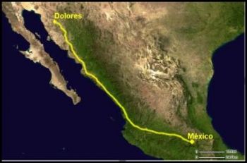
To Mexico City To Defend O'odham People
1,500 Miles in 53 Days
1695 - 1696
November 16, 1695 January 8, 1696
To Mexico City
53 days, 1,500 miles, average about 30 miles/day
Padre Kino
Kino goes to Mexico City to secure the peace in the Pimeria Alta, to prevent missions from closing and to advocate for Jesuit return to Baja
Route: Dolores to Camino de Real Occidental, Guadalajara, Mexico City.
Also see the El Camino Real Occidental map at top of page.

Return from Mexico City
1696
February 1696 - mid May, 1696
Return from Mexico City
Kino escapes death by leaving his military escort and visiting fellow Jesuits in Sierra Madres
Kino
Route: Mexico City, Guadalajara and on Camino de Real Occidental, Guasavas, Guachinera, Santa Maria de Bazeraca, Babispe; thence back to Guasavas by same route; thence via Oposura, Cumpas, Guepaca (Valle de Sonora), Opodepe, Tuape, and Cucurpe, to Dolores
Expedition 15
Also see See the El Camino Real Occidental map at top of page.
1696
December, 1696- January, 1697
To Quiburi and Bac
Kino
Route: Dolores, Remedios, Cocospera, Santa Maria de Bugota, Basosucan, Santa Cruz, Quiburi, Bac, Tumacacori, Guevavi, Bacoancos, San Lazaro, Cocospera, Remedios, Dolores
Expedtion 16
1697
March, 1697
To Quiburi and Tumacacori
Kino Route: Dolores, Remedios, Cocospera, Santa Maria de Bugota, Basosucan, Quiburi, Los Reyes de Sonoidag, Tumacacori, Guevavi, Bacoancos, San Lazaro, Cocospera, Remedios, Dolores
Expedition 17
1697
March, 1697
To Quiburi and Tumacacori
Kino Route: Dolores, Remedios, Cocospera, Santa Maria de Bugota, Basosucan, Quiburi, Los Reyes de Sonoidag, Tumacacori, Guevavi, Bacoancos, San Lazaro, Cocospera, Remedios, Dolores
Expedition 17
1697
September-October, 1697
To Bazeraca
Petition Jesuit Provicial
Kino and Pima Chiefs
Route: Dolores, Cucurpe, Tuape, Opodepe, Guepaca (Valle de Sonora), Real de Juan, Cumpas, Oposura, Guasavas, Guachinera, Bazeraca Return by the same route
Expedtion 18
North Down the San Pedro River
To Visit Western Sobaipuris
1697
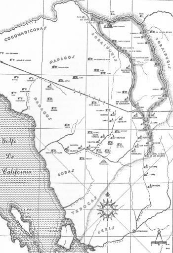
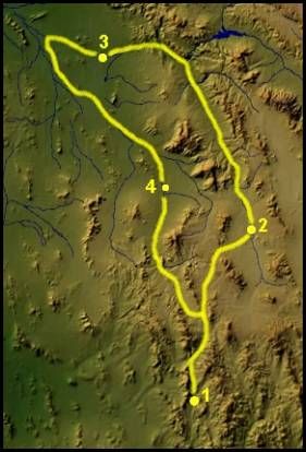
November 2-December 2, 1697 (See Map Above)
North Down the San Pedro River
Visit Western Sobaipuiris and show military that Sobaipuris not raiding Spanish settlements.
30 days, 650 miles, average 21.6 miles/day, 4,700 native people counted
Padre Kino and Captains Bernal and Manje
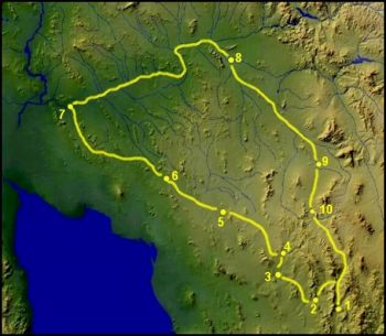
Route: Kino and Manje from Dolores via Remedios, Cocospera, San Lazaro, Santa Maria de Bugota (where they were joined by Bernal coming from Santa Rosa de Corodeguachij ; thence all via Basosucan, Quiburi, Arivavia, and down the Rio San Pedro and the Rio Gila to Casa Grande, Encarnacion, and San Andres Return via Santa Catalina, San Agustin, Tucson, Bac, Tumacacori, Guevavi, San Lazaro, Cocospera, Remedios, Dolores
Expedition 19
Dolores (1), Quíburi (2), Casa Grande (3), Bac (4) Dolores (1).
1698
February, 1698
To Tucubavia and Caborca
Padres Kino and Barrillas, Lieutenant Ramos Sarmiento and Captain Manje
Route: Dolores, Magdalena, El Tupo, El Bosna, Tubutama, Saric, Busanic, Tucubavia; thence back to Tubutama, and via Santa Teresa, Oquitoa, Altar, and Pitquin to Caborca Return via Tubutama and Magdalena to Dolores
Expedition 20
April, 1698
To Quiburi
Make report of Sobaipuri major victory over raiding native people
Kino and Manje
Route: Dolores, Remedios, Cocospera, San Lazaro, Santa Maria de Bugota, Basosucan, Quiburi; thence via Santa Cruz and Terrenate to Santa Rosa de Corodeguachi (Fronteras), and back by same route to Quiburi, Return by the original route to Dolores
Expedition 21
For More Information on the Following Colorado River Expeditions
Expeditions 22 through 29
Click Explore Colorado River and Delta
To Sierra de Santa Clara (Pinacate Summit) From Middle Gila River
Across Today's O'odham Lands
1698
September 22- October 18, 1698
To the Gila River and the Sierra de Santa Clara (Pinacates)
Kino and Captain Carrasco through O'odham Land
Route: Dolores, Remedios, Cocospera, San Lazaro, Bacoancos, Guevavi, Tumacacori, Bac, Tucson, San Agustin, Santa Catalina, Encarnacion, San Andres; thence south via San Angelo del Borum, San Bonifacio, San Francisco del Adid, La Merced del Batki, San Rafael del Actum Grande, San Marcelo de Sonoita, Quitovaquita, El Carrizal, Sierra de Santa Clara (Pinacate) Return via Sonoita, Bacapa (Moicaqui), Bacpia, Caborca, Tubutama, Magdalena, Dolores
Expeditiion 22
Trip A
Dolores (1), Tumacácori (2), Bac (3), San Andrés (4), Sonoita (5), Pinacate Summit (6), Quitovac (7), Caborca (8), Tubutama (9),
Dolores (1).
To Lower Gila River to visit Cocomaricopas and Yumas
via Sonoita and Camino del Diablo
1699
February 7-March 14, 1699 (Map 5)
To the Rio Gila to visit Cocomaricopas and Yumas via Sonoita and Camino del Diablo
35 days, 950 miles, average 27 miles/day, 1,800 native men counted
Padres Kino and Gilg, and Captain Manje
Route: Dolores, San Ignacio, Magdalena, EI Tupo, Tubutama, Saric, Busanic, Tucubavia, Gubo Verde (San Estanislao del Ootcam) , Santa Eulalia, San Rafael, Sonoita, Quitovaquita, Carrizal; thence over Camino del Diablo via Aguaje de la Luna and Agua Escondida to San Pedro on the Rio Gila; thence to San Pablo and back; thence up the Rio Gila to San Matias and on through Cocomaricopa rsncberies; across great bend of Gila from San Felipe (last Cocomaricopa villages), to San Bartolome; thence via San Andres, Encarnacion, Santa Catalina, Bac, Tumacacori, Guevavi, San Lazaro, Cocospera and Remedios to Dolores
Expedition 23
Trip 1
Dolores (1), Magdalena (2), Tubutama (3), Tucubavia (4), Pozo Verde (5), Sonoita (6), San Pedro (7), San Andrés (8), San Xavier del Bac (9), Tumacácori (10), Dolores (1).
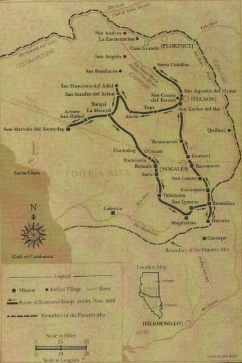
To San Xavier del Bac through O'odham Lands to Sonoita
1699
October 24-November 18, 1699 (See Map Above)
To Bac and through O'odham Land to Sonoita
25 days, 675 miles, average 27 miles/day, 1,800 native people not previously counted
Padres Kino, Leal and Gonzalez, and Captain Manje
Route: Dolores, Remedios, Cocospera, San Lazaro, Bacoancos, Guevavi, Tumacacori, Bac, Tucson, San Agustin, Santa Catalina; thence back to Bac, and west to Tupo, Cups, San Serafin del Actum Chico, San Francisco del Adid, Batki, San Rafael, Butoburro, San Bonifacio; thence back to San Rafael, and on to Sonoita Return via San Rafael, Santa Eulalia, Tucubavia, Busanic, Saric, Tubutama, Magdalena to Dolores
Expedition 24
Trip B
1700
April 21-May 6, 1700
To Bac
Laying foundiations for first church at San Xavier; Blue Shell Conference; Rescue Condemned Man
Kino
Dolores, Remedios, Cocospera, San Lazaro, Bacoancos, Guevavi, Tumacacori, San Xavier del Bac Work begun on church, April 28. Return by the same route to Dolores
Expedition 25
Trip C
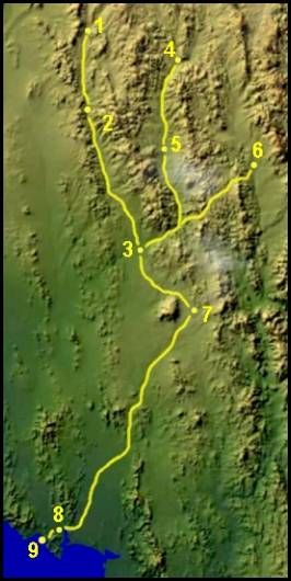
To Guaymus with Baja Food Relief
1700
June 1700 and October 1700
To Guaymus
Collection of Cattle and other supplies for Baja Mission Food Relief
Kino and O'odham Vaqueros
Dolores (1), Tuape (2), Ures (3), Arizpe (4), Huépac (5), Oposura [Moctezuma] (6), Mátape (7), San José de Guaymas (8),
Guaymas (9).
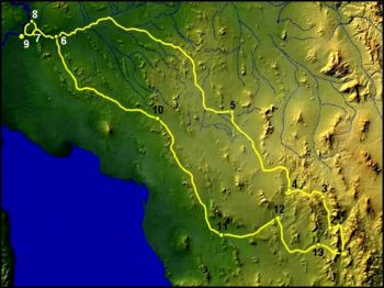
To Junction of the Lower Gila River and the Colorado River -
Today's Yuma, Arizona
1700
September 24 - October 20, 1700
To Junction of the Gila and the Colorado Rivers
Kino
Visit Yumas
Route: Dolores, Remedios, Imuris, San Simon y San Judas del Siboda, Busanic, Tucubavia, San Estanislao, Santa Eulalia, Santa Ana del Anamic, Batki, San Geronimo (El Comac), El Tutto; thence down the Gila through the Cocomaricopa villages to San Pedro, San Pablo and San Dionisio in the Yuma country Return up river to San Pedro, thence over Camino del Diablo to Sonoita, and via Bacapa, Bacpia, Caborca, Tubutama, San Ignacio, Magdalena, Imuris and Remedios to Dolores
Expedition 26
Trip 2
Dolores (1), Imuris (2), Cíbuta (3), Búsanic (4),Merced del Batki (5), San Pedro (6), Gila Mountains to view the Gulf (7), Las Sandías (8), Dionisio {Yuma] (9), Sonoita (10), Caborca (11), Tubutama (12), Magdalena (13), Dolores(1).
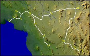
To Find Route Around the Gulf of California Via Colorado Delta with Salvatierra
1701
February 27 - April 16, 1701 (See above Map)
Finding land route to Baja is very urgent with the wreck of the San Fermin, the main supply ship to Salvatierra's Baja mission. Also the frigate San Jose is in need of immediate repair.
48 days, 950 miles, average 20 miles/day, 400 native people counted
To Puerto de Santa Clara (near Puerto Penasco)
Padres Kino and Salvatierra and Captain Manje
Route: Assembled at Caborca, March 10; thence to Bacpia, Bacapa, Sonoita, Quitovaquita, Carrizal, Sucoybutobavia, San Jose de Ramos, Santa Brigida, Puerto de Santa Clara (Adair Bay) Return to Carrizal by the same route; thence northwest of Sierra de Santa Clara to Pitaqui Return to Carrizal and thence to Sonoita Salvatierra back to Dolores via Caborca, Tubutama and Magdalena Kino and Manje via Sonoita, San Rafael, Gubo, Batki, San Serafin, Tupo, Bac, Tumacacori, Guevavi, San Lazaro, Cocospera, Remedios, Dolores
Expedition 27
Trip D
Caborca (1), Arivaipa (2), Quitovac (3), Sonoita (4), Basoitutcan (5), Tupo (6), Ojitos (7), Pinacate Summit to view Gulf (8), Kino Return after (8): Merced (9), Bac (10), Tubutama (11), Magdalena(12), Dolores(13). Salavatierra return after (8): Sonoita (4), Quitovac (3), Arivaipa (2), Caborca (1), Magdalena (12).
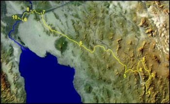
To Alta Calfornia - Crossing the Colorado River
1701
November 3-December 8, 1701
Crosses Colorado River to California and then down to the lower Colorado River
Visits Quiquimas and bargains for food relief to Yumas
Kino
Route: Dolores, Remedios, Cocospera, San Lazaro, Bacoancos, Guevavi; thence south to Busanic, Tucubavia, and west via San Estanislao, Santa Eulalia, Santa Ana, San Rafael, Sonoita, Quitovaquita, Carrizal, and over Camino del Diablo to San Pedro on the Gila; thence via San Pablo, San Dionisio, Santa Ysabel, San Feliz, and across the Colorado to La Presentacion, in Quiquima country Return by same route to Sonoita; thence via Santa Sabina, Santa Ana, Santa Eulalia, San Estanislao, Tucubavia, Busanic, Imuris, Remedios; Dolores
Expedition 28
Trip 3
Dolores (1), Cocóspera (2), Guévavi (3), Cíbuta (4), Búsanic (5), Sonoita (6), San Pedro (7), San Dionisio [Yuma] (8), San Félix (9), La Presentación (10). Return same route except bypass Cíbuta (4) to Dolores (1).
1706
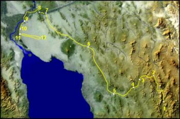
To The Head of the Gulf of California and Colorado River Delta
1702
February 5-March 31, 1702
To Delta of Colorado River and head of the Gulf of California
Kino's last journey to the Gila or Colorado and Fr. Gonzalez death at Tubutama
Kino and Gonzalez
Route: Dolores, Remedios, Imuris, San Simon y San Judas, Busanic, Tucubavia, San Estanislao, Santa Eulalia, Santa Sabina, San Rafael, Sonoita, Quitovaquita, Carrizal, and over Camino del Diablo to San Pedro on the Gila; thence via San Pablo, San Dionisio, Santa Ysabel, San Feliz, San Rodesindo and San Casimiro to head of the Gulf of California and Colorado River Delta. Vain attempt to return through desert to eastward; back to San Casimiro Return by the same route to Busanic; thence to Tubutama, where Gonzalez was left by Kino, who went on to Dolores via El Tupo and Magdalena Gonzalez would die at the Tubutama mission.
Expedition 29
Trip 4
Dolores (1), Cíbuta (2), Búsanic (3), Tubutama (4), Caborca (5), Sonoita (6), San Pedro (7), San Pablo (8), San Félix (9), San Rudencindo (10), San Casimiro (11), End of Colorado River Delta and Head of the Gulf of California (not shown on map), Return from failed attempt to take short route through Great Sand Dunes (12).
1702
September, 1702
Construction of churches at Caborca, El Saric, Busanic and San Xavier del Bac
Kino
Route: Dolores, Caborca, EI Saric, San Ambrosio del Busanic, San Xavier del Bac and return to Dolores.
Exploration 29A
Not shown on Bolton Map.
1704
February, 1704
To Tubutama and Guaymas
Installation of Padre Minutili at Tubutama
Padres Kino and Minutili
Route: Dolores, Magdalena, El Tupo, El Bosna, Tubutama Return by Saric, San Simon y San Judas, Imuris, and Remedios to Dolores March-April Kino to Guaymas: Dolores, Cucurpe, Tuape, Opodepe, Santa Maria del Populo, San Francisco, Pitic, San Jose de Guaymas Return by substantially the same route
Expedition 30 and Expedition 31
1706
January, 1706
To the Seris on Tepoca coast on Gulf of California
Discovers Tiburon is an island
Padres Kino and Minutili
Route: Caborca, Unuicat; thence west and south along Sierra Picu to coast, near Isla Tiburon Return by substantially the same route, except for a side trip east of Sierra del Viejo
Expedition 32
February, 1706
To Caborca
Discover new cattle trail to recently settled port of Guaymas
Kino
Route: Dolores, Remedios, Babasaqui, Cocospera, Imuris, San Simon y San Judas, Busanic, Saric, Tubutama, Santa Teresa, Oquitoa, Altar, Pitquin, Caborca Return by the same route to Tubutama; thence via El Bosna, El Tupo and Magdalena to Dolores
Expedition 33
1706
February, 1706
To Caborca
Discover new cattle trail to recently settled port of Guaymas
Kino
Route: Dolores, Remedios, Babasaqui, Cocospera, Imuris, San Simon y San Judas, Busanic, Saric, Tubutama, Santa Teresa, Oquitoa, Altar, Pitquin, Caborca Return by the same route to Tubutama; thence via El Bosna, El Tupo and Magdalena to Dolores
Expedition 33
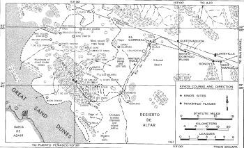
To Sierra de Santa Clara (Pinacate Mountains)
Kino's Last Major Journey of Exploration
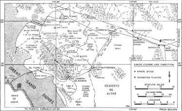
(Detail Map of Pinacate Volcanic Fields)
1706
October 22-November 16, 1706 (See above Detail Map of Pinacate Volcanic Fields)
To Sierra de Santa Clara (Pinacate Mountains)
View head of Gulf of California with official witnesess to verify that California is not an island
Kino's last journey of exploration
Padre Kino, Fray Oyuela, Captain Ramirez and Commandant Duran
Route: Dolores, Remedios, Babasaqui, Cocospera, Imuris, San Simon y San Judas, Busanic, Saric, Tubutama, Santa Teresa, Oquitoa, Altar, Pirquin, Caborca, Bacpia, Bacapa, Sonoita, Quitovaquita, Carrizal, Sierra de Santa Clara Return by the same route to Sonoita: thence via San Rafael, Santa Sabina, Santa Ana, Santa Eulalia, San Estanislao, Busanic, Saric, Tubutama, El Bosna, El Tupo and Magdalena to Dolores
Expedition 35
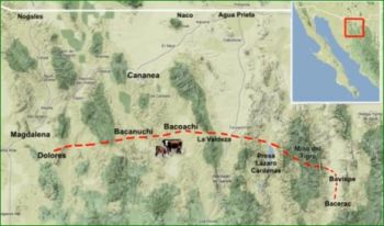
1711
March 14 - 15, 1711
To Magdalena
Kino dies after dedicating chapel at Magdalena -
End of Kino's earthly trails
Kino
Route: Dolores and Magdalena
Expedition 37
To Explorer Colorado River and Delta Page
Detail narrative about Expeditons 23 through 29
Return to Main Explorer Page: Explorer Section Page
